|
search place name
|
||
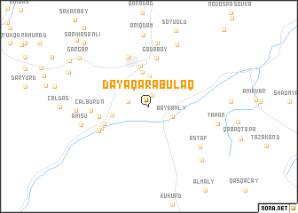
Dǝyǝqarabulaq (Gǝdǝbǝy, Azerbaijan)Dǝyǝqarabulaq is a town in the Gǝdǝbǝy region of Azerbaijan. An overview map of the region around Dǝyǝqarabulaq is displayed below.
regional and 3d topo map of Dǝyǝqarabulaq, Azerbaijan ::
Nearby towns ::
Şurakǝnd (1.4km north) //
Musayal (2.1km west) //
Bayramly (2.5km south east) //
Düzyurd (3.7km north) //
Yenikend (4.4km north) //
Rüstǝm Əliyev (3.7km west) //
Kiçik Düzyürd (5.2km north) //
Kalakend (4.8km south west) //
Gǝdǝbǝy (6.1km north) //
Balakend (5.0km west) //
Plankǝnd (5.3km south west) //
Qarıkǝnd (6.5km north) //
Əlinağılar (5.7km south west) //
Çalburun (5.6km west) //
Mağara (8.1km north) //
Astaf (7.0km south east) //
Qumlu (8.2km north) //
Arısu (6.8km west) //
Tapan (6.9km east) //
Shaumyan (8.5km south east) //
Gǝrgǝr (9.0km north west) //
Sarıhǝsǝnli (10.2km north west) //
[all distances 'as the bird flies' and approximate] 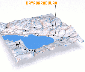 Places with similar names to Dǝyǝqarabulaq, Azerbaijan :: Disclaimer :: Information on this page comes without warranty of any kind |
||
|
Where is Dǝyǝqarabulaq? Elevation and coordinates ::
Latitude (lat): 40°30'40"N Longitude (lon): 45°48'26"E
Elevation (approx.): 1524m (map arrows pan, magnifying glasses zoom) |
||
|
Visiting Dǝyǝqarabulaq? Hotel/Accommodation ::
Book a hotel in Dǝyǝqarabulaq Travel Guide ::
Buy a travel guide for Azerbaijan rental cars ::
car rental offers GPS waypoint ::
download a GPX waypoint (PoI) of Dǝyǝqarabulaq for your GPS receiver
|
||