|
search place name
|
||
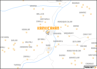
Kǝrkicahan (Xocalı, Azerbaijan)Kǝrkicahan is a town in the Xocalı region of Azerbaijan. An overview map of the region around Kǝrkicahan is displayed below.
regional and 3d topo map of Kǝrkicahan, Azerbaijan ::
Kǝrkicahan airports ::
The nearest airport is TBZ - Tabriz Intl, located 190.7 km south of Kǝrkicahan.
Nearby towns ::
Xankǝndi (1.3km north) //
Fakhlul (2.1km north west) //
Daşkǝnd (2.9km east) //
Qeybalı (3.6km south west) //
Xanyurdu (4.9km north) //
Cǝmilli (4.7km north west) //
Şuşa (5.3km south) //
Şuşakǝnd (4.8km south east) //
Muxtar (5.1km south east) //
Malıbǝyli (4.7km north east) //
Laçınlar (5.5km south west) //
Daşaltı (6.9km south) //
Aşağı Quşçular (6.2km north east) //
Ballıca (7.3km north) //
Dağdağan (6.1km east) //
Yuxarı Kuşçular (6.6km north east) //
Şuşulu (7.3km south west) //
Xǝlfǝli (7.0km south west) //
Kosalar (6.6km west) //
Zamanpǝyǝsi (8.9km south west) //
[all distances 'as the bird flies' and approximate] 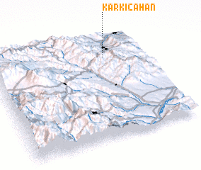 Places with similar names to Kǝrkicahan, Azerbaijan ::
Disclaimer :: Information on this page comes without warranty of any kind |
||
|
Where is Kǝrkicahan? Elevation and coordinates ::
Latitude (lat): 39°48'13"N Longitude (lon): 46°45'1"E
Elevation (approx.): 857m (map arrows pan, magnifying glasses zoom) |
||
|
Visiting Kǝrkicahan? Hotel/Accommodation ::
Book a hotel in Kǝrkicahan Travel Guide ::
Buy a travel guide for Azerbaijan rental cars ::
car rental offers GPS waypoint ::
download a GPX waypoint (PoI) of Kǝrkicahan for your GPS receiver
|
||