|
search place name
|
||
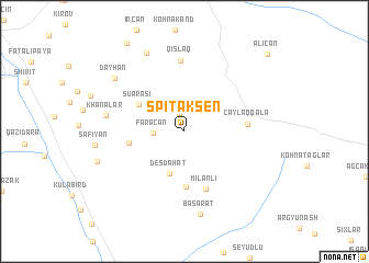
Spitakşen (Xocavǝnd, Azerbaijan)Spitakşen is a town in the Xocavǝnd region of Azerbaijan. An overview map of the region around Spitakşen is displayed below.
regional and 3d topo map of Spitakşen, Azerbaijan ::
Spitakşen airports ::
The nearest airport is TBZ - Tabriz Intl, located 161.4 km south of Spitakşen.
Nearby towns ::
Arpagǝdik (1.9km north) //
Fǝrǝcan (2.5km west) //
Deşdahat (4.4km south) //
Suarası (4.5km north west) //
Hat (5.6km south) //
Aşağı Fǝrǝcan (4.5km west) //
Milanlı (6.0km south) //
Çaylaqqala (5.0km east) //
Qışlaq (7.2km north) //
Khanalar (6.4km west) //
Başarat (8.6km south) //
Dǝyhan (7.6km north west) //
Xumarta (8.5km north) //
Kushchular (7.5km south west) //
Alıcan (10.2km north east) //
[all distances 'as the bird flies' and approximate] 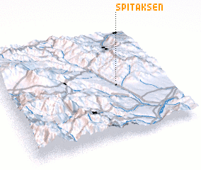 Places with similar names to Spitakşen, Azerbaijan ::
// Spitakşen (AZ)
Disclaimer :: Information on this page comes without warranty of any kind |
||
|
Where is Spitakşen? Elevation and coordinates ::
Latitude (lat): 39°32'20"N Longitude (lon): 46°42'42"E
Elevation (approx.): 1320m (map arrows pan, magnifying glasses zoom) |
||
|
Visiting Spitakşen? Hotel/Accommodation ::
Book a hotel in Spitakşen Travel Guide ::
Buy a travel guide for Azerbaijan rental cars ::
car rental offers GPS waypoint ::
download a GPX waypoint (PoI) of Spitakşen for your GPS receiver
|
||