|
search place name
|
||
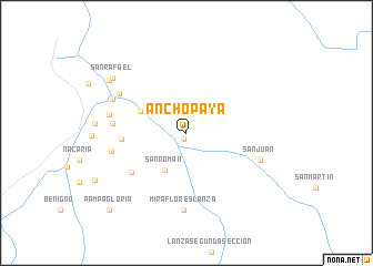
Anchopaya (La Paz, Bolivia)Anchopaya is a town in the La Paz region of Bolivia. An overview map of the region around Anchopaya is displayed below.
regional and 3d topo map of Anchopaya, Bolivia ::
Anchopaya airports ::
The nearest airport is PEM - Puerto Maldonado Padre Aldamiz, located 163.3 km north of Anchopaya.
Other airports nearby include JUL - Juliaca (208.4 km south west), Nearby towns ::
Palmerani (0.7km south west) //
San Román (4.3km south west) //
San Lorenzo (5.0km north west) //
Alto Urubamba (6.3km west) //
Janansaya (6.7km south west) //
Urubamba (7.3km west) //
Miraflores Lanza (7.7km south) //
San Pedro (7.6km west) //
Sillacunca (7.7km north west) //
San Juan (7.7km east) //
Curva Alegre (7.7km west) //
Misquimayo (8.0km north west) //
San Rafael (9.1km north west) //
Pauji Playa (9.1km north west) //
Pampa Gloria (10.8km south west) //
[all distances 'as the bird flies' and approximate] 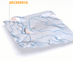 Places with similar names to Anchopaya, Bolivia :: Disclaimer :: Information on this page comes without warranty of any kind |
||
|
Where is Anchopaya? Elevation and coordinates ::
Latitude (lat): 14°3'0"S Longitude (lon): 68°53'0"W
Elevation (approx.): 963m (map arrows pan, magnifying glasses zoom) |
||
|
Visiting Anchopaya? Hotel/Accommodation ::
Book a hotel in Anchopaya Travel Guide ::
Buy a travel guide for Bolivia rental cars ::
car rental offers GPS waypoint ::
download a GPX waypoint (PoI) of Anchopaya for your GPS receiver
|
||