|
search place name
|
||
La Paz (La Paz, Bolivia)La Paz is a town in the La Paz region of Bolivia. An overview map of the region around La Paz is displayed below.
regional and 3d topo map of La Paz, Bolivia ::

La Paz airports ::
The nearest airport is LPB - La Paz El Alto Intl, located 4.7 km west of La Paz.
Other airports nearby include CBB - Cochabamba Jorge Wilsterman (233.5 km south east), Nearby towns ::
Callampaya (1.8km west) //
Challapampa (1.9km north) //
Chijini (1.8km east) //
Pura Pura (2.6km north west) //
San Jorge (2.6km south east) //
Villa Pabón (2.6km north east) //
Allpacoma (3.7km south) //
Usina (4.1km north west) //
Mojón de Lima (4.0km north west) //
Llojeta (4.1km south east) //
Caiconi (4.1km north east) //
Obrajes (5.1km south east) //
Pata Patani (5.8km north) //
Huaripampa (5.8km north) //
Mojón de Achocalla (6.6km south west) //
Chuquiaguillo (6.6km north east) //
Irpavi (6.5km south east) //
Calacoto (6.5km south east) //
Muhancani (7.4km south) //
Chacaltaya (7.4km north) //
Jancocollo (7.6km south) //
Aranjuez (7.7km south east) //
Següencoma (7.7km south east) //
Kenko (9.1km south west) //
[all distances 'as the bird flies' and approximate] 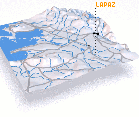 Places with similar names to La Paz, Bolivia ::
Disclaimer :: Information on this page comes without warranty of any kind |
||
|
Where is La Paz? Elevation and coordinates ::
Latitude (lat): 16°30'0"S Longitude (lon): 68°9'0"W
Elevation (approx.): 3781m (map arrows pan, magnifying glasses zoom) |
||
|
Visiting La Paz? Hotel/Accommodation ::
Book a hotel in La Paz Travel Guide ::
Buy a travel guide for Bolivia rental cars ::
car rental offers GPS waypoint ::
download a GPX waypoint (PoI) of La Paz for your GPS receiver
|
||