|
search place name
|
||
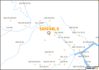
San Pablo (La Paz, Bolivia)San Pablo is a town in the La Paz region of Bolivia. An overview map of the region around San Pablo is displayed below.
regional and 3d topo map of San Pablo, Bolivia ::
San Pablo airports ::
The nearest airport is LPB - La Paz El Alto Intl, located 126.3 km south of San Pablo.
Nearby towns ::
Colpaña (1.8km east) //
Vicote (2.6km south west) //
Culebra (3.6km east) //
Zouponte (3.7km north) //
Achiquiri (3.7km north) //
Carura (4.0km north east) //
Pilcara (5.1km north west) //
Qunqueri (5.1km north west) //
Cuereano (5.6km north) //
Tutilimundi (5.7km east) //
Carrera (6.6km north west) //
Urupata (7.4km south) //
Guelequelera (7.7km south east) //
Pelera (8.1km south east) //
[all distances 'as the bird flies' and approximate] 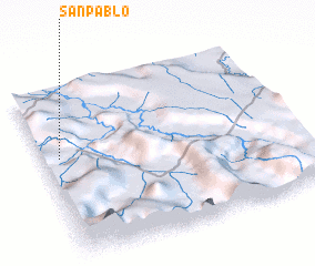 Places with similar names to San Pablo, Bolivia ::
Disclaimer :: Information on this page comes without warranty of any kind |
||
|
Where is San Pablo? Elevation and coordinates ::
Latitude (lat): 15°24'0"S Longitude (lon): 67°56'0"W
Elevation (approx.): 1460m (map arrows pan, magnifying glasses zoom) |
||
|
Visiting San Pablo? Hotel/Accommodation ::
Book a hotel in San Pablo Travel Guide ::
Buy a travel guide for Bolivia rental cars ::
car rental offers GPS waypoint ::
download a GPX waypoint (PoI) of San Pablo for your GPS receiver
|
||