|
search place name
|
||
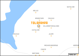
Tolapampa (Potosí, Bolivia)Tolapampa is a town in the Potosí region of Bolivia. An overview map of the region around Tolapampa is displayed below.
regional and 3d topo map of Tolapampa, Bolivia ::
Tolapampa airports ::
The nearest airport is CJC - Calama El Loa, located 221.4 km south west of Tolapampa.
Nearby towns ::
San Juan Río (0.0km north) //
Cutulcha (2.5km south west) //
Angostura (3.7km north) //
Villa Martín Colchak (5.2km east) //
Jilapi (6.4km south east) //
Chilala (6.4km north east) //
Malila (7.6km north) //
[all distances 'as the bird flies' and approximate] 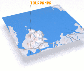 Places with similar names to Tolapampa, Bolivia ::
// Tolapampa (BO)
// Tolapampa (BO)
// Tolapampa (BO)
// Tolapampa (BO)
// Tolapampa (BO)
// Tallapampa (PE)
// Tallapampa (PE)
// Talapampa (AR)
Disclaimer :: Information on this page comes without warranty of any kind |
||
|
Where is Tolapampa? Elevation and coordinates ::
Latitude (lat): 20°46'0"S Longitude (lon): 67°50'0"W
Elevation (approx.): 3827m (map arrows pan, magnifying glasses zoom) |
||
|
Visiting Tolapampa? Hotel/Accommodation ::
Book a hotel in Tolapampa Travel Guide ::
Buy a travel guide for Bolivia rental cars ::
car rental offers GPS waypoint ::
download a GPX waypoint (PoI) of Tolapampa for your GPS receiver
|
||