|
search place name
|
||
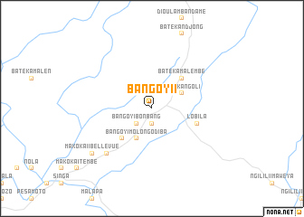
Bangoy II (Cameroon)Bangoy II is a town in Cameroon. An overview map of the region around Bangoy II is displayed below.
regional and 3d topo map of Bangoy II, Cameroon ::
Bangoy II airports ::
The nearest airport is OUE - Ouesso, located 97.5 km south east of Bangoy II.
Nearby towns ::
Bangoy I (1.9km south) //
Bangoy I Bonbang (2.6km south west) //
Batéka Ngoli (4.1km north east) //
Bangoy I Molongodiba (4.1km south west) //
Batéka Malembé (5.2km north east) //
Banana Kéka (5.2km south west) //
Banana (5.2km south west) //
Lobila (5.9km east) //
Makoka II (7.9km south west) //
Makoka I (9.3km south west) //
Makoka II Bellevue (9.3km south west) //
[all distances 'as the bird flies' and approximate]  Places with similar names to Bangoy II, Cameroon ::
// Bangayao (PH)
// Ban Ka Yi (TH)
// Ban Ka Yi (TH)
// Ban Ka Yu (TH)
// Ban Ko Yai (TH)
// Ban Ko Yai (TH)
// Ban Ko Yai (TH)
// Ban Ko Yai (TH)
// Ban Ko Yai I (TH)
// Ban Ko Yao (TH)
Disclaimer :: Information on this page comes without warranty of any kind |
||
|
Where is Bangoy II? Elevation and coordinates ::
Latitude (lat): 2°7'0"N Longitude (lon): 15°19'0"E
Elevation (approx.): 437m (map arrows pan, magnifying glasses zoom) |
||
|
Visiting Bangoy II? Hotel/Accommodation ::
Book a hotel in Bangoy II Travel Guide ::
Buy a travel guide for Cameroon rental cars ::
car rental offers GPS waypoint ::
download a GPX waypoint (PoI) of Bangoy II for your GPS receiver
|
||