|
search place name
|
||
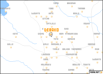
Débako (Cameroon)Débako is a town in Cameroon. An overview map of the region around Débako is displayed below.
regional and 3d topo map of Débako, Cameroon ::
Débako airports ::
The nearest airport is GOU - Garoua, located 85.3 km north east of Débako.
Other airports nearby include YOL - Yola (97.0 km north west), NGE - N'gaoundere Ngaoundere (151.9 km south), MVR - Maroua Salak (240.8 km north east), Nearby towns ::
Bora (1.9km south) //
Yawalé (1.8km east) //
Béka (1.8km west) //
Ilou (1.9km north) //
Tété (2.6km south east) //
Wébako (2.6km north west) //
Bori (3.7km east) //
Giding (3.7km west) //
Eptilélé (3.7km north) //
Bérengté (4.1km south east) //
Nangwalé (4.1km south east) //
Kinlé (4.1km south west) //
Gitcha (5.9km north) //
Siko (5.8km east) //
Batilbako (5.9km north) //
Tinglé (5.9km south) //
Noumsé (5.9km south) //
Douka Notcha (7.4km south) //
Fignolé (7.4km south) //
Goundé (7.4km north) //
Waté (7.4km north) //
Nyaourédou (7.3km east) //
Paté Boldou (7.6km south) //
Lougéré (7.6km south) //
Dongko (7.6km east) //
Doulé (7.6km north) //
Balkoa (7.8km south east) //
Soumi (8.3km south west) //
Boli (8.3km north west) //
[all distances 'as the bird flies' and approximate] 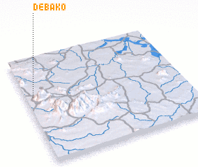 Places with similar names to Débako, Cameroon ::
Disclaimer :: Information on this page comes without warranty of any kind |
||
|
Where is Débako? Elevation and coordinates ::
Latitude (lat): 8°38'0"N Longitude (lon): 13°3'0"E
Elevation (approx.): 322m (map arrows pan, magnifying glasses zoom) |
||
|
Visiting Débako? Hotel/Accommodation ::
Book a hotel in Débako Travel Guide ::
Buy a travel guide for Cameroon rental cars ::
car rental offers GPS waypoint ::
download a GPX waypoint (PoI) of Débako for your GPS receiver
|
||