|
search place name
|
||
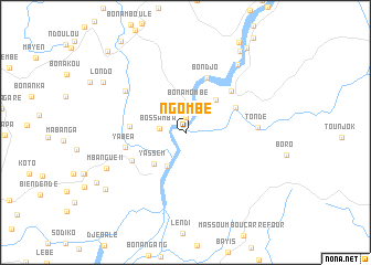
Ngombé (Littoral, Cameroon)Ngombé is a town in the Littoral region of Cameroon. An overview map of the region around Ngombé is displayed below.
regional and 3d topo map of Ngombé, Cameroon ::
Ngombé airports ::
The nearest airport is DLA - Douala, located 24.5 km south of Ngombé.
Other airports nearby include TKC - Tiko (48.3 km west), SSG - Malabo (129.1 km south west), BFX - Bafoussam (159.1 km north east), CBQ - Calabar (179.1 km north west), Nearby towns ::
Bonépéa (1.5km north) //
Bossamba (2.6km west) //
Bonamombé (3.0km north) //
Bonangando (3.8km south west) //
Moundja Moussadi (4.4km north east) //
Yassem (4.5km south west) //
Bongo (5.6km west) //
Mboume (5.7km north east) //
Bondjo (6.0km north) //
Yassouka (6.1km south west) //
Moutimbelembé (6.2km north east) //
Yabéa (6.3km west) //
Tondé (7.3km east) //
Moussoko (7.4km north west) //
Bonindi (8.7km north east) //
Mbangué II (8.8km south west) //
Londo (9.8km north west) //
Nono (9.9km north east) //
Mbangué I (9.9km south west) //
Bwéné (10.5km north east) //
Miang (11.3km north west) //
[all distances 'as the bird flies' and approximate]  Places with similar names to Ngombé, Cameroon ::
Disclaimer :: Information on this page comes without warranty of any kind |
||
|
Where is Ngombé? Elevation and coordinates ::
Latitude (lat): 4°13'15"N Longitude (lon): 9°46'30"E
Elevation (approx.): 22m (map arrows pan, magnifying glasses zoom) |
||
|
Visiting Ngombé? Hotel/Accommodation ::
Book a hotel in Ngombé Travel Guide ::
Buy a travel guide for Cameroon rental cars ::
car rental offers GPS waypoint ::
download a GPX waypoint (PoI) of Ngombé for your GPS receiver
|
||