|
search place name
|
||
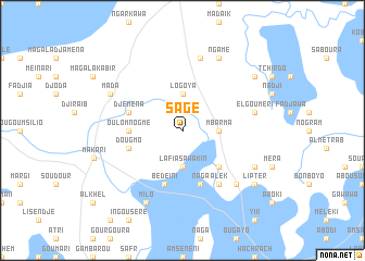
Sagé (Cameroon)Sagé is a town in Cameroon. An overview map of the region around Sagé is displayed below.
regional and 3d topo map of Sagé, Cameroon ::
Sagé airports ::
The nearest airport is NDJ - N'djamena Ndjamena Hassan Djamous, located 75.0 km south east of Sagé.
Other airports nearby include MIU - Maiduguri (178.2 km south west), Nearby towns ::
Lafia Sawakin (3.7km south) //
Dolé (3.7km south) //
Dougmo (3.7km south) //
Logoya (3.7km north) //
Mbarma (3.6km east) //
Krénak I (5.2km south east) //
Oulomnogmé (5.4km west) //
Bédéini (5.8km south) //
Naga (5.8km south) //
Lafia (5.8km south) //
Djéména (5.7km west) //
Dougmo (5.7km west) //
Alek (6.6km south east) //
El Goumeri (7.5km east) //
Abou Dangala (7.6km north) //
Tchabouté (7.8km south east) //
Héroua (8.1km north west) //
Mada (8.1km north west) //
Biang Do (8.1km south east) //
Biang (8.1km south east) //
Milo (8.2km south west) //
Ngamé (8.2km north east) //
Lipter (9.1km south east) //
Oueilonaga (9.1km north east) //
[all distances 'as the bird flies' and approximate] 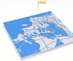 Places with similar names to Sagé, Cameroon ::
Disclaimer :: Information on this page comes without warranty of any kind |
||
|
Where is Sagé? Elevation and coordinates ::
Latitude (lat): 12°36'0"N Longitude (lon): 14°32'0"E
Elevation (approx.): 288m (map arrows pan, magnifying glasses zoom) |
||
|
Visiting Sagé? Hotel/Accommodation ::
Book a hotel in Sagé Travel Guide ::
Buy a travel guide for Cameroon rental cars ::
car rental offers GPS waypoint ::
download a GPX waypoint (PoI) of Sagé for your GPS receiver
|
||