|
search place name
|
||
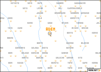
Ādem (Ethiopia)Ādem is a town in Ethiopia. An overview map of the region around Ādem is displayed below.
regional and 3d topo map of Ādem, Ethiopia ::
Ādem airports ::
The nearest airport is ADD - Addis Ababa Bole Intl, located 61.4 km south east of Ādem.
Other airports nearby include JIM - Jimma (244.7 km south west), Nearby towns ::
Sība (0.0km north) //
Ātʼīla (2.6km south east) //
Setʼē (2.6km north east) //
Mīnīso (2.6km north east) //
Sokʼī (2.6km north east) //
Dodē (3.7km north) //
Bortē (5.2km south west) //
Ākeyu (5.9km south) //
Gebero (5.9km south) //
Ēla (6.7km north west) //
Ādī Feyiso (6.7km south west) //
Inchʼīnī (6.6km north east) //
Bentē (7.3km east) //
Hārbu (7.6km south) //
Baka (7.8km south west) //
Deladu (7.8km south west) //
Deka Bora (8.3km south west) //
Shīno (8.2km north west) //
Āgemsa (8.2km south east) //
Jewīsa (8.3km north west) //
Bīshan Dīmo (8.3km north east) //
Dēbīsa (9.2km south east) //
Kʼorīcha (9.2km south west) //
Falē (9.2km north west) //
Lefo (9.2km north east) //
Buyema (9.2km south east) //
[all distances 'as the bird flies' and approximate]  Places with similar names to Ādem, Ethiopia ::
Disclaimer :: Information on this page comes without warranty of any kind |
||
|
Where is Ādem? Elevation and coordinates ::
Latitude (lat): 9°17'0"N Longitude (lon): 38°20'0"E
Elevation (approx.): 2536m (map arrows pan, magnifying glasses zoom) |
||
|
Visiting Ādem? Hotel/Accommodation ::
Book a hotel in Ādem Travel Guide ::
Buy a travel guide for Ethiopia rental cars ::
car rental offers GPS waypoint ::
download a GPX waypoint (PoI) of Ādem for your GPS receiver
|
||