|
search place name
|
||
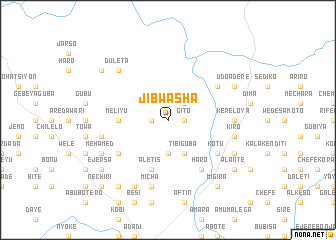
Jib Washa (Ethiopia)Jib Washa is a town in Ethiopia. An overview map of the region around Jib Washa is displayed below.
regional and 3d topo map of Jib Washa, Ethiopia ::
Jib Washa airports ::
The nearest airport is ADD - Addis Ababa Bole Intl, located 119.5 km south of Jib Washa.
Other airports nearby include BJR - Bahar Dar Bahir Dar (215.0 km north west), LLI - Lalibella (229.2 km north), Nearby towns ::
Gītʼo (1.8km east) //
Borebor (1.8km west) //
Ējersa (2.6km north east) //
Meko (3.7km south) //
Tʼībī Guba (4.1km south east) //
Melīyu (5.5km west) //
Āletʼīs (5.9km south) //
Deso (6.6km south west) //
Hāro (6.7km south east) //
Fīnchʼawa (6.6km south east) //
Kʼotu (6.6km south east) //
Līben (6.6km north east) //
Kʼerē Loya (7.3km east) //
Wezemī (7.3km east) //
Mīchʼa (7.6km south) //
Kīro (7.5km east) //
Mogoro (7.5km west) //
Duleta (7.8km north west) //
Yaya Āmbena (8.3km south west) //
Dewa (8.3km south west) //
Mehāmed (8.2km south west) //
Weldē (8.2km south east) //
Tulu Lemtu (8.2km north east) //
Udo Āderē (8.2km north east) //
Mamē (9.2km south west) //
Mīgīra (9.2km south east) //
Ālantē (9.2km south east) //
Kʼedīda (9.2km north west) //
Ējersa (9.2km south west) //
[all distances 'as the bird flies' and approximate] 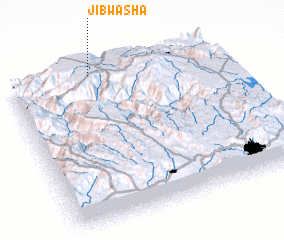 Places with similar names to Jib Washa, Ethiopia :: Disclaimer :: Information on this page comes without warranty of any kind |
||
|
Where is Jib Washa? Elevation and coordinates ::
Latitude (lat): 9°59'0"N Longitude (lon): 38°24'0"E
Elevation (approx.): 2363m (map arrows pan, magnifying glasses zoom) |
||
|
Visiting Jib Washa? Hotel/Accommodation ::
Book a hotel in Jib Washa Travel Guide ::
Buy a travel guide for Ethiopia rental cars ::
car rental offers GPS waypoint ::
download a GPX waypoint (PoI) of Jib Washa for your GPS receiver
|
||