|
search place name
|
||
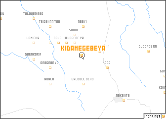
Kʼidamē Gebeya (Welega, Ethiopia)Kʼidamē Gebeya is a town in the Welega region of Ethiopia. An overview map of the region around Kʼidamē Gebeya is displayed below.
regional and 3d topo map of Kʼidamē Gebeya, Ethiopia ::
Kʼidamē Gebeya airports ::
The nearest airport is JIM - Jimma, located 170.4 km south of Kʼidamē Gebeya.
Other airports nearby include ASO - Asosa (226.9 km north west), GMB - Gambella (238.9 km south west), Nearby towns ::
Tsʼigē Maryam (4.1km north east) //
Ihud Gebeya (4.1km north west) //
Dengalē Gonkē (5.2km north west) //
Galo Belochʼo (5.6km south) //
Shunē (5.9km north) //
Haro (5.8km east) //
Bolo (6.6km north west) //
Ābeyī (7.4km north) //
Kolobo (7.5km west) //
‘Arb Gebeya (7.5km west) //
Ādīya Mīchīrē (8.2km north west) //
Wereseyo (8.2km north west) //
Ābalo (9.2km south west) //
Tsʼigē Maryam (10.4km north west) //
[all distances 'as the bird flies' and approximate] 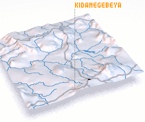 Places with similar names to Kʼidamē Gebeya, Ethiopia ::
Disclaimer :: Information on this page comes without warranty of any kind |
||
|
Where is Kʼidamē Gebeya? Elevation and coordinates ::
Latitude (lat): 9°10'0"N Longitude (lon): 36°28'0"E
Elevation (approx.): 1782m (map arrows pan, magnifying glasses zoom) |
||
|
Visiting Kʼidamē Gebeya? Hotel/Accommodation ::
Book a hotel in Kʼidamē Gebeya Travel Guide ::
Buy a travel guide for Ethiopia rental cars ::
car rental offers GPS waypoint ::
download a GPX waypoint (PoI) of Kʼidamē Gebeya for your GPS receiver
|
||