|
search place name
|
||
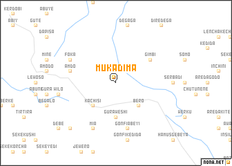
Muka Dīma (Ethiopia)Muka Dīma is a town in Ethiopia. An overview map of the region around Muka Dīma is displayed below.
regional and 3d topo map of Muka Dīma, Ethiopia ::
Muka Dīma airports ::
The nearest airport is ADD - Addis Ababa Bole Intl, located 125.5 km south east of Muka Dīma.
Other airports nearby include BJR - Bahar Dar Bahir Dar (226.4 km north), JIM - Jimma (246.4 km south west), Nearby towns ::
Bero (5.2km south east) //
Kachīsī (5.2km south west) //
Gura Weshī (5.6km south) //
Gīmbī (6.6km north east) //
Gonfī Ābeyī (7.6km south) //
Āmdo (7.5km west) //
Ādīno (7.5km west) //
Mīʼā (8.3km south west) //
Lubu Tʼenī (8.3km south west) //
Fokʼa (8.2km north west) //
Damotīcha (8.2km north west) //
Goro Menga (10.4km south west) //
[all distances 'as the bird flies' and approximate] 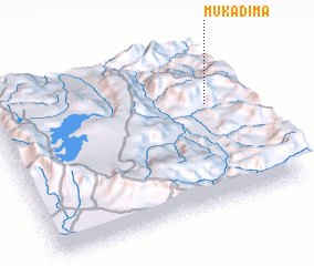 Places with similar names to Muka Dīma, Ethiopia ::
// Mikitamäe (EE)
// McAdam (US)
// Makadémé (TD)
// Makoudoumi (TD)
// Macotama (CO)
// Mukuadiambo (CD)
// Macadioum (GA)
// Macadium (GA)
// Macadium (GA)
// Moctum (MX)
Disclaimer :: Information on this page comes without warranty of any kind |
||
|
Where is Muka Dīma? Elevation and coordinates ::
Latitude (lat): 9°38'0"N Longitude (lon): 37°52'0"E
Elevation (approx.): 2125m (map arrows pan, magnifying glasses zoom) |
||
|
Visiting Muka Dīma? Hotel/Accommodation ::
Book a hotel in Muka Dīma Travel Guide ::
Buy a travel guide for Ethiopia rental cars ::
car rental offers GPS waypoint ::
download a GPX waypoint (PoI) of Muka Dīma for your GPS receiver
|
||