|
search place name
|
||
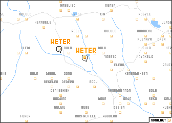
Weter (Ethiopia)Weter is a town in Ethiopia. An overview map of the region around Weter is displayed below.
regional and 3d topo map of Weter, Ethiopia ::
Weter airports ::
The nearest airport is DIR - Dire Dawa Intl, located 30.7 km north of Weter.
Nearby towns ::
Bululo (2.6km north east) //
Langē (2.6km north east) //
Dulu (4.1km north east) //
Bulo (4.1km north west) //
Goro (5.2km south west) //
Gola (5.6km north) //
Yabeto (5.5km east) //
Boru (5.9km south) //
Weter (5.8km west) //
Beda (5.9km south) //
Āgelo (5.9km north) //
Mēta (5.8km east) //
Dedero (6.7km south west) //
Chʼululo (6.7km south west) //
Chʼelo (6.7km south west) //
Ēlēmo (7.5km east) //
Bululo (7.8km north east) //
Debal (8.2km south west) //
Dermē Shēk (9.2km south west) //
Gadula (9.2km south west) //
Bekʼelen (9.2km south west) //
Āhmed Gerada (10.4km south east) //
[all distances 'as the bird flies' and approximate] 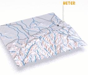 Places with similar names to Weter, Ethiopia ::
Disclaimer :: Information on this page comes without warranty of any kind |
||
|
Where is Weter? Elevation and coordinates ::
Latitude (lat): 9°21'0"N Longitude (lon): 41°49'0"E
Elevation (approx.): 1991m (map arrows pan, magnifying glasses zoom) |
||
|
Visiting Weter? Hotel/Accommodation ::
Book a hotel in Weter Travel Guide ::
Buy a travel guide for Ethiopia rental cars ::
car rental offers GPS waypoint ::
download a GPX waypoint (PoI) of Weter for your GPS receiver
|
||