|
search place name
|
||
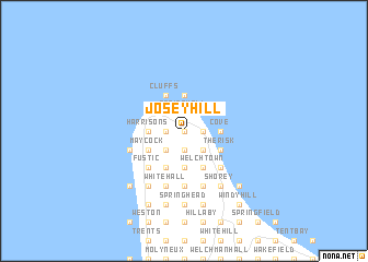
Josey Hill (Saint Lucy, Barbados)Josey Hill is a town in the Saint Lucy region of Barbados. An overview map of the region around Josey Hill is displayed below.
regional and 3d topo map of Josey Hill, Barbados ::
Josey Hill airports ::
The nearest airport is BGI - Bridgetown Grantley Adams Intl, located 27.5 km south east of Josey Hill.
Other airports nearby include UVF - Hewandorra Hewanorra Intl (154.1 km west), SLU - Castries George F L Charles (170.5 km north west), SVD - Kingstown E T Joshua (175.4 km west), MQS - Mustique (177.3 km west), Nearby towns ::
Bishops (0.0km north) //
Jemmotts (0.0km north) //
Mount Gay (0.0km north) //
Lowland (0.0km north) //
Pickerings (0.0km north) //
Durham (0.0km north) //
Mount Pleasant (0.0km north) //
Mount View (0.0km north) //
Free Hill (0.0km north) //
Spring Hall (1.9km north) //
Cottage (1.9km south) //
Seaview (1.9km north) //
Flatfield (1.9km north) //
Hope (1.9km north) //
Alexandra (1.9km south) //
Chance Hall (1.9km north) //
Coconut Hall (1.9km north) //
Rock Hall (1.9km south) //
Oxford (1.9km south) //
Trents (1.8km west) //
Fairfield (1.8km west) //
Cave Hill (1.8km east) //
Harris (1.8km west) //
Mount Royer (1.8km west) //
Pie Corner (1.8km east) //
Lamberts (1.8km east) //
Rockfield (1.8km east) //
Blacksage Alley (1.8km east) //
Well Road (1.8km east) //
[all distances 'as the bird flies' and approximate]  Places with similar names to Josey Hill, Barbados :: Disclaimer :: Information on this page comes without warranty of any kind |
||
|
Where is Josey Hill? Elevation and coordinates ::
Latitude (lat): 13°18'0"N Longitude (lon): 59°36'0"W
Elevation (approx.): 121m (map arrows pan, magnifying glasses zoom) |
||
|
Visiting Josey Hill? Hotel/Accommodation ::
Book a hotel in Josey Hill Travel Guide ::
Buy a travel guide for Barbados rental cars ::
car rental offers GPS waypoint ::
download a GPX waypoint (PoI) of Josey Hill for your GPS receiver
|
||