|
search place name
|
||
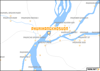
Phumĭ Hang Khosuŏn (Stœ̆ng Trêng, Cambodia)Phumĭ Hang Khosuŏn is a town in the Stœ̆ng Trêng region of Cambodia. An overview map of the region around Phumĭ Hang Khosuŏn is displayed below.
regional and 3d topo map of Phumĭ Hang Khosuŏn, Cambodia ::
Phumĭ Hang Khosuŏn airports ::
The nearest airport is PKZ - Pakse, located 176.4 km north of Phumĭ Hang Khosuŏn.
Nearby towns ::
Phumĭ Srê Poŭthĭ (1.9km south) //
Phumĭ Thalabârĭvăt (3.6km west) //
Phumĭ Sakhun (3.6km east) //
Stœ̆ng Trêng (4.1km south west) //
Kaôh Mak Hvai (4.1km north east) //
Phumĭ Dŏng Ta Dăm (4.1km south east) //
Phumĭ Ta Dêt (5.7km east) //
Phumĭ Cheung Preăh Bat (5.7km west) //
Phumĭ Bœ̆ng Krâmuŏn (6.6km north east) //
Phumĭ Kăng Mémay (6.6km south west) //
Phumĭ Ânlóng Svay (6.6km south west) //
Phumĭ Srê Năm Nây (7.2km east) //
Phumĭ Hang Savat (7.2km east) //
Phumĭ Chan Ta Ngŭy (7.4km east) //
Phumĭ Kăng Dei Sâr (8.2km south west) //
Phumĭ Srê Rœssei (9.1km north west) //
Phumĭ Kbal Kaôh (10.3km south west) //
[all distances 'as the bird flies' and approximate]  Places with similar names to Phumĭ Hang Khosuŏn, Cambodia :: Disclaimer :: Information on this page comes without warranty of any kind |
||
|
Where is Phumĭ Hang Khosuŏn? Elevation and coordinates ::
Latitude (lat): 13°33'0"N Longitude (lon): 105°59'0"E
Elevation (approx.): 58m (map arrows pan, magnifying glasses zoom) |
||
|
Visiting Phumĭ Hang Khosuŏn? Hotel/Accommodation ::
Book a hotel in Phumĭ Hang Khosuŏn Travel Guide ::
Buy a travel guide for Cambodia rental cars ::
car rental offers GPS waypoint ::
download a GPX waypoint (PoI) of Phumĭ Hang Khosuŏn for your GPS receiver
|
||