|
search place name
|
||
Phumĭ Kŏk Slŏng (Siĕm Réab, Cambodia)Phumĭ Kŏk Slŏng is a town in the Siĕm Réab region of Cambodia. An overview map of the region around Phumĭ Kŏk Slŏng is displayed below.
regional and 3d topo map of Phumĭ Kŏk Slŏng, Cambodia ::

Phumĭ Kŏk Slŏng airports ::
The nearest airport is REP - Siem-reap Siem Reap, located 53.9 km north west of Phumĭ Kŏk Slŏng.
Other airports nearby include PNH - Phnom-penh Phnom Penh Intl (189.4 km south), PKZ - Pakse (275.7 km north east), Nearby towns ::
Phumĭ Prey Prás (1.9km south) //
Phumĭ Thnál Dăch (2.6km north east) //
Phumĭ Sâsâr Khmor (3.7km north) //
Phumĭ O Kraôm (4.1km north west) //
Phumĭ Thnál Ta Sĕt (5.4km east) //
Phumĭ Yéang (5.8km north) //
Phumĭ O Leu (5.8km north) //
Phumĭ Bœ̆ng Thum (6.6km north west) //
Phumĭ Bœ̆ng Vêng (6.6km north west) //
Phumĭ Kroch (7.4km north) //
Phumĭ Rœssei Lôk (7.4km north) //
Phumĭ Béng (1) (7.5km east) //
Phumĭ Koŭk Dei (7.8km north west) //
Phumĭ Don Sŏk (8.1km south east) //
Phumĭ Sâmraông Kânhchaôch (9.2km north west) //
Phumĭ Chikrêng (9.1km south east) //
Phumĭ Sala Kâkaôh (10.3km north west) //
Phumĭ Béng (1) (10.3km south east) //
[all distances 'as the bird flies' and approximate] 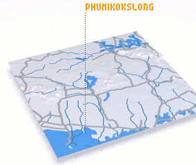 Places with similar names to Phumĭ Kŏk Slŏng, Cambodia :: Disclaimer :: Information on this page comes without warranty of any kind |
||
|
Where is Phumĭ Kŏk Slŏng? Elevation and coordinates ::
Latitude (lat): 13°9'0"N Longitude (lon): 104°14'0"E
Elevation (approx.): 13m (map arrows pan, magnifying glasses zoom) |
||
|
Visiting Phumĭ Kŏk Slŏng? Hotel/Accommodation ::
Book a hotel in Phumĭ Kŏk Slŏng Travel Guide ::
Buy a travel guide for Cambodia rental cars ::
car rental offers GPS waypoint ::
download a GPX waypoint (PoI) of Phumĭ Kŏk Slŏng for your GPS receiver
|
||