|
search place name
|
||
Phumĭ Lvéa Sâr Kândal (Bântéay Méan Cheăy, Cambodia)Phumĭ Lvéa Sâr Kândal is a town in the Bântéay Méan Cheăy region of Cambodia. An overview map of the region around Phumĭ Lvéa Sâr Kândal is displayed below.
regional and 3d topo map of Phumĭ Lvéa Sâr Kândal, Cambodia ::

Phumĭ Lvéa Sâr Kândal airports ::
The nearest airport is PNH - Phnom-penh Phnom Penh Intl, located 40.3 km west of Phumĭ Lvéa Sâr Kândal.
Other airports nearby include SGN - Ho Chi Minh City Tansonnhat Intl (173.3 km south east), REP - Siem-reap Siem Reap (264.2 km north west), Nearby towns ::
Phumĭ Lvéa Sâr Kraôm (0.0km north) //
Vôtt Chey Môngkól (1.9km south) //
Phumĭ Bœ̆ng Krum Kraôm (1.8km west) //
Phumĭ Prêk Yuŏn (2.6km south east) //
Phumĭ Bântéay Dêk (3.6km west) //
Phumĭ Chŏng Kaôh (2) (3.6km west) //
Phumĭ Prêk Chrey (4.1km north east) //
Phumĭ Chroŭy Dâng (4.1km south east) //
Phumĭ Kânlêng Krâbei (4.1km south east) //
Phumĭ Prêk Ânteăh (4.1km north east) //
Phumĭ Prêk Phkŏâm (4.1km north east) //
Phumĭ Chŏng Prêk Pŏl (4.1km south west) //
Phumĭ Bœ̆ng Krum Kândal (4.1km north west) //
Phumĭ Bœ̆ng Krum (5.2km north west) //
Phumĭ Prêk Rœssei (5.4km east) //
Phumĭ Kândal Kraôm (5.4km west) //
Phumĭ Prêk Âmpĭl (5.8km east) //
Phumĭ Kândal Leu (5.8km west) //
Phumĭ Stœ̆ng (6.6km south east) //
Phumĭ Rumlĭch (6.6km south east) //
Phumĭ Pôngrô (6.6km south east) //
Phumĭ Prêk Char (6.6km south east) //
Phumĭ Sâmbuŏr (6.6km south east) //
Phumĭ Mdŭm (6.6km north west) //
Phumĭ Chrăng Tôtœ̆ng (7.6km north) //
Phumĭ Dei Dŏh (7.8km south east) //
Phumĭ Chroŭy Chrê (7.8km south east) //
Phumĭ Prêk Trêng (9.2km south east) //
Phumĭ Tœ̆k Khleăng (9.1km north west) //
[all distances 'as the bird flies' and approximate] 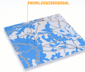 Places with similar names to Phumĭ Lvéa Sâr Kândal, Cambodia :: Disclaimer :: Information on this page comes without warranty of any kind |
||
|
Where is Phumĭ Lvéa Sâr Kândal? Elevation and coordinates ::
Latitude (lat): 11°27'0"N Longitude (lon): 105°12'0"E
Elevation (approx.): 8m (map arrows pan, magnifying glasses zoom) |
||
|
Visiting Phumĭ Lvéa Sâr Kândal? Hotel/Accommodation ::
Book a hotel in Phumĭ Lvéa Sâr Kândal Travel Guide ::
Buy a travel guide for Cambodia rental cars ::
car rental offers GPS waypoint ::
download a GPX waypoint (PoI) of Phumĭ Lvéa Sâr Kândal for your GPS receiver
|
||