|
search place name
|
||
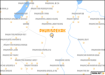
Phumĭ Srê Kák (Kâmpóng Cham, Cambodia)Phumĭ Srê Kák is a town in the Kâmpóng Cham region of Cambodia. An overview map of the region around Phumĭ Srê Kák is displayed below.
regional and 3d topo map of Phumĭ Srê Kák, Cambodia ::
Phumĭ Srê Kák airports ::
The nearest airport is PNH - Phnom-penh Phnom Penh Intl, located 131.5 km west of Phumĭ Srê Kák.
Other airports nearby include SGN - Ho Chi Minh City Tansonnhat Intl (148.9 km south east), Nearby towns ::
Phumĭ Prâlaôh Tbong (3.7km north) //
Phumĭ Bânghêk Tey (4.1km south west) //
Phumĭ Prâlaôh Cheung (5.8km north) //
Phumĭ Koŭk Srâlau (6.6km south west) //
Phumĭ Svay Pak (8.3km north west) //
Phumĭ Takêv (9.1km north east) //
Phumĭ Kântuŏt (10.4km north east) //
[all distances 'as the bird flies' and approximate] 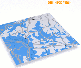 Places with similar names to Phumĭ Srê Kák, Cambodia :: Disclaimer :: Information on this page comes without warranty of any kind |
||
|
Where is Phumĭ Srê Kák? Elevation and coordinates ::
Latitude (lat): 11°59'0"N Longitude (lon): 105°58'0"E
Elevation (approx.): 78m (map arrows pan, magnifying glasses zoom) |
||
|
Visiting Phumĭ Srê Kák? Hotel/Accommodation ::
Book a hotel in Phumĭ Srê Kák Travel Guide ::
Buy a travel guide for Cambodia rental cars ::
car rental offers GPS waypoint ::
download a GPX waypoint (PoI) of Phumĭ Srê Kák for your GPS receiver
|
||