|
search place name
|
||
Phumĭ Tuŏl Kôki (Kaôh Kŏng, Cambodia)Phumĭ Tuŏl Kôki is a town in the Kaôh Kŏng region of Cambodia. An overview map of the region around Phumĭ Tuŏl Kôki is displayed below.
regional and 3d topo map of Phumĭ Tuŏl Kôki, Cambodia ::

Phumĭ Tuŏl Kôki airports ::
The nearest airport is PNH - Phnom-penh Phnom Penh Intl, located 193.9 km east of Phumĭ Tuŏl Kôki.
Other airports nearby include REP - Siem-reap Siem Reap (219.5 km north), Nearby towns ::
Phumĭ Péam Krâsaôb (0.0km north) //
Phumĭ Kaôh Lây (1.9km south) //
Phumĭ Takat (3.7km south) //
Phumĭ Prêk Svay (3.6km west) //
Phumĭ Taman (4.1km north west) //
Phumĭ Kaôh Chăs (4.1km south west) //
Phumĭ Srê Thmei (4.1km south west) //
Phum Dong (7.3km east) //
Phumĭ Prêk Kduŏch (7.6km south) //
Phumĭ Prêk Pôpél (8.3km south east) //
Phumĭ Péam Krâsaôb (1) (9.8km south west) //
[all distances 'as the bird flies' and approximate] 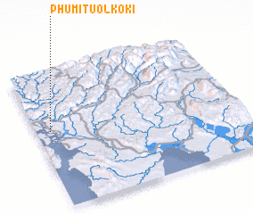 Places with similar names to Phumĭ Tuŏl Kôki, Cambodia ::
// Phumĭ Tuŏl Kâkaôh (KH)
Disclaimer :: Information on this page comes without warranty of any kind |
||
|
Where is Phumĭ Tuŏl Kôki? Elevation and coordinates ::
Latitude (lat): 11°34'0"N Longitude (lon): 103°4'0"E
Elevation (approx.): 61m (map arrows pan, magnifying glasses zoom) |
||
|
Visiting Phumĭ Tuŏl Kôki? Hotel/Accommodation ::
Book a hotel in Phumĭ Tuŏl Kôki Travel Guide ::
Buy a travel guide for Cambodia rental cars ::
car rental offers GPS waypoint ::
download a GPX waypoint (PoI) of Phumĭ Tuŏl Kôki for your GPS receiver
|
||