|
search place name
|
||
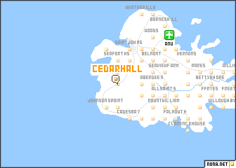
Cedar Hall (Saint Mary, Antigua and Barbuda)Cedar Hall is a town in the Saint Mary region of Antigua and Barbuda. An overview map of the region around Cedar Hall is displayed below.
regional and 3d topo map of Cedar Hall, Antigua and Barbuda ::
Cedar Hall airports ::
The nearest airport is ANU - Antigua V C Bird Intl, located 11.1 km north east of Cedar Hall.
Other airports nearby include SKB - Basse Terre Robert L Bradshaw (94.6 km west), PTP - Pointe-a-pitre Le Raizet (95.6 km south), EUX - Oranjestad F D Roosevelt (127.5 km west), SFG - St. Martin Grand Case (169.6 km north west), Nearby towns ::
Blubber Valley (0.0km north) //
Yorks (1.9km north) //
Jennings (1.9km north) //
Ebenezer (1.9km north) //
New Division (1.9km north) //
Seaforths (3.7km north) //
Urlings (3.7km south) //
Harveys (3.7km south) //
Orange Valley Mill (3.7km south) //
Emanuel (3.5km east) //
Saint Lukes (3.5km east) //
Bendals (3.5km east) //
Grays Hill (4.1km north east) //
Crab Hill (4.1km south west) //
Johnsons Point (4.1km south west) //
Bolans (4.1km south west) //
Hamiltons (4.0km south east) //
Golden Grove (5.1km north east) //
Creekside (5.1km north east) //
Buckleys (5.3km east) //
Aberdeen (5.3km east) //
Five Islands Village (5.8km north) //
Potters Village (5.6km east) //
Green Bay (5.8km north) //
Saint Johnʼs (5.8km north) //
Cades Bay (5.8km south) //
Sawcolts (5.6km east) //
John Hughes (5.6km east) //
Belmont (6.5km north east) //
[all distances 'as the bird flies' and approximate]  Places with similar names to Cedar Hall, Antigua and Barbuda ::
// Cedar Hill (US)
// Cedar Hill (US)
// Star Hill (US)
// Sutter Hill (US)
// Star Hill (US)
// Cedar Hill (US)
// Cedar Hill (US)
// Cedarhill (US)
// Storheil (NO)
// Sátorhely (HU)
Disclaimer :: Information on this page comes without warranty of any kind |
||
|
Where is Cedar Hall? Elevation and coordinates ::
Latitude (lat): 17°4'0"N Longitude (lon): 61°52'0"W
Elevation (approx.): 20m (map arrows pan, magnifying glasses zoom) |
||
|
Visiting Cedar Hall? Hotel/Accommodation ::
Book a hotel in Cedar Hall Travel Guide ::
rental cars ::
car rental offers GPS waypoint ::
download a GPX waypoint (PoI) of Cedar Hall for your GPS receiver
|
||