|
search place name
|
||
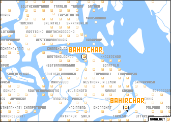
Bāhir Char (Barisāl, Bangladesh)Bāhir Char is a town in the Barisāl region of Bangladesh. An overview map of the region around Bāhir Char is displayed below.
regional and 3d topo map of Bāhir Char, Bangladesh ::
Bāhir Char airports ::
The nearest airport is DAC - Dhaka Zia Intl, located 95.4 km north of Bāhir Char.
Other airports nearby include IXA - Agartala (128.6 km north east), JSR - Jessore (133.9 km west), CGP - Chittagong Shah Amanat Intl (162.0 km south east), IRD - Ishurdi (192.9 km north west), Nearby towns ::
Lāmchari Tum Char (NaNkm north) //
Dumurtala (NaNkm north) //
Char Dumurtala (1.9km south) //
Krishnapura (1.7km west) //
Saidergrām (1.7km west) //
Tum Char (1.7km east) //
Char Gāchhua (2.5km south west) //
South Gāchhua (2.5km south west) //
Harināthpur (2.5km south east) //
Purbba Kāndi (2.5km south east) //
Char Dhaleswar (2.5km south west) //
Abupur (2.5km north west) //
Gangāpur (3.4km east) //
North Char Narsinhapur (3.7km south) //
North Gāchhua (3.4km west) //
Srīmati (3.4km west) //
Memāniār Kolchar (3.9km south east) //
Mahishkhola (3.9km south east) //
Ābupur (3.9km north east) //
Char Balarampur (4.1km south west) //
Char Pakshya (4.1km south west) //
Kolchar Harināthpur (4.1km south east) //
Char Kolānia (4.1km south west) //
Pakshya (4.1km south west) //
Badarpur (4.1km north east) //
Tar Dahali (5.0km south east) //
Kālikāpur (5.0km south east) //
Char Dahali (5.0km south east) //
Hosanābād (5.0km south west) //
[all distances 'as the bird flies' and approximate]  Places with similar names to Bāhir Char, Bangladesh ::
// Bāher Char (BD)
// Bāher Char (BD)
// Bāher Char (BD)
// Bāher Char (BD)
// Bāher Char (BD)
// Bāher Char (BD)
// Bāher Char (BD)
// Bāher Char (BD)
// Bāher Char (BD)
// Bāher Char (BD)
Disclaimer :: Information on this page comes without warranty of any kind |
||
|
Where is Bāhir Char? Elevation and coordinates ::
Latitude (lat): 22°59'0"N Longitude (lon): 90°27'0"E
Elevation (approx.): 3m (map arrows pan, magnifying glasses zoom) |
||
|
Visiting Bāhir Char? Hotel/Accommodation ::
Book a hotel in Bāhir Char Travel Guide ::
Buy a travel guide for Bangladesh rental cars ::
car rental offers GPS waypoint ::
download a GPX waypoint (PoI) of Bāhir Char for your GPS receiver
|
||