|
search place name
|
||
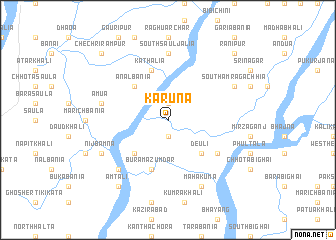
Karuna (Barisāl, Bangladesh)Karuna is a town in the Barisāl region of Bangladesh. An overview map of the region around Karuna is displayed below.
regional and 3d topo map of Karuna, Bangladesh ::
Karuna airports ::
The nearest airport is JSR - Jessore, located 136.0 km north west of Karuna.
Other airports nearby include DAC - Dhaka Zia Intl (165.5 km north), CGP - Chittagong Shah Amanat Intl (171.9 km east), CCU - Calcutta Netaji Subhash Chandra Bose Intl (178.1 km west), IXA - Agartala (202.0 km north east), Nearby towns ::
Hāt Mokāmia (1.9km north) //
Chhopkhāli (1.9km south) //
Ānalbania (5.0km north west) //
Deuli (5.0km south east) //
Charkhāli (5.0km south west) //
Kathālia (5.8km north) //
Bura Mazumdar (5.8km south) //
Dhanmānikya Chatra (6.3km south east) //
South Sauljālia (7.4km north) //
Āmua (7.1km west) //
Bāmna (7.6km south west) //
Mahakuma (8.2km south east) //
South Āmrāgāchhia (7.8km north east) //
Nij Bāmna (7.8km south west) //
Āmtali (9.0km south west) //
Rānīpur (10.1km north east) //
Chechri Rāmpur (10.1km north west) //
[all distances 'as the bird flies' and approximate]  Places with similar names to Karuna, Bangladesh ::
Disclaimer :: Information on this page comes without warranty of any kind |
||
|
Where is Karuna? Elevation and coordinates ::
Latitude (lat): 22°22'0"N Longitude (lon): 90°9'0"E
Elevation (approx.): 6m (map arrows pan, magnifying glasses zoom) |
||
|
Visiting Karuna? Hotel/Accommodation ::
Book a hotel in Karuna Travel Guide ::
Buy a travel guide for Bangladesh rental cars ::
car rental offers GPS waypoint ::
download a GPX waypoint (PoI) of Karuna for your GPS receiver
|
||