|
search place name
|
||
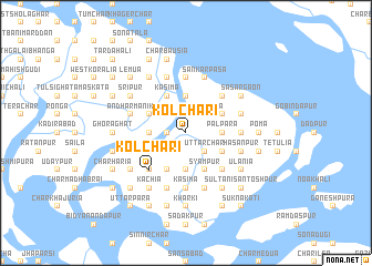
Kol Chari (Barisāl, Bangladesh)Kol Chari is a town in the Barisāl region of Bangladesh. An overview map of the region around Kol Chari is displayed below.
regional and 3d topo map of Kol Chari, Bangladesh ::
Kol Chari airports ::
The nearest airport is DAC - Dhaka Zia Intl, located 107.5 km north of Kol Chari.
Other airports nearby include IXA - Agartala (131.7 km north east), JSR - Jessore (146.2 km west), CGP - Chittagong Shah Amanat Intl (147.7 km south east), IRD - Ishurdi (207.9 km north west), Nearby towns ::
Āsighar (1.9km north) //
Bāhir Char (1.7km west) //
Uttar Char (2.5km south east) //
Lashkarpur (2.5km south west) //
Sauldi (2.5km south east) //
North Dādpurer Char (2.5km south west) //
Lakshmipur Bāher Char (2.5km north west) //
Dhul Khola (2.5km north east) //
Bāher Char (2.5km north west) //
Basupatti (2.5km north east) //
Tegāchhia (2.5km north east) //
Char Bāusiār Ghordaur (3.4km west) //
East Purbba Kāndi (3.7km south) //
Pālpāra (3.4km east) //
Char Hijla (3.7km north) //
Darbeser Kāndi (3.9km south west) //
Char Ilsa (3.9km south west) //
Tar Ilsa (3.9km south west) //
Bālia (3.9km south east) //
Khuna Gobindapur (3.9km north west) //
Syāmpur (4.1km south east) //
Rāmnāthpur (4.1km south west) //
Madhyakāndi (4.1km south west) //
Kāsipur (4.1km south east) //
West Purbba Kāndi (4.1km south west) //
Gangācharan (4.1km south east) //
Hāmider Tek (4.1km south west) //
Kunjapatti (3.9km north east) //
Bāthua (3.9km north east) //
[all distances 'as the bird flies' and approximate]  Places with similar names to Kol Chari, Bangladesh ::
Disclaimer :: Information on this page comes without warranty of any kind |
||
|
Where is Kol Chari? Elevation and coordinates ::
Latitude (lat): 22°53'0"N Longitude (lon): 90°33'0"E
Elevation (approx.): 4m (map arrows pan, magnifying glasses zoom) |
||
|
Visiting Kol Chari? Hotel/Accommodation ::
Book a hotel in Kol Chari Travel Guide ::
Buy a travel guide for Bangladesh rental cars ::
car rental offers GPS waypoint ::
download a GPX waypoint (PoI) of Kol Chari for your GPS receiver
|
||