|
search place name
|
||
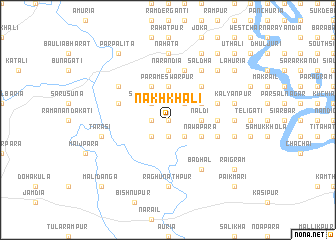
Nakh Khāli (Barisāl, Bangladesh)Nakh Khāli is a town in the Barisāl region of Bangladesh. An overview map of the region around Nakh Khāli is displayed below.
regional and 3d topo map of Nakh Khāli, Bangladesh ::
Nakh Khāli airports ::
The nearest airport is JSR - Jessore, located 37.6 km west of Nakh Khāli.
Other airports nearby include IRD - Ishurdi (109.1 km north west), DAC - Dhaka Zia Intl (110.3 km north east), CCU - Calcutta Netaji Subhash Chandra Bose Intl (129.0 km south west), RJH - Rajshahi Shah Mokhdum (158.8 km north west), Nearby towns ::
Mithāpur (0.0km north) //
Nayābāri (0.0km north) //
Brāhmaninagar (1.9km south) //
North Bāgdānga (1.9km south) //
Hārighara (1.7km west) //
North Singa (1.7km west) //
Dari Mithāpur (1.7km west) //
Masa Khāli (2.5km north east) //
Kālāchāndpur (2.5km south east) //
Sujāpur (2.5km north west) //
Nālia (2.5km north west) //
Swarupdipur (2.5km north west) //
Jaydebpur Dumairtala (2.5km south west) //
Naldi (3.4km east) //
Mobārakpur (3.7km north) //
Parameswarpur (3.7km north) //
Bīl Ichhāmati (3.9km north east) //
Nawāpāra (3.9km south east) //
Jayrāmpur (4.1km north west) //
Jhāmārghop (5.0km north east) //
Kalāgāchhia (5.0km north east) //
Haldaha (5.1km east) //
Nārāndia (5.6km north) //
Ārāzi Mandalgāti (5.4km east) //
Pulum (5.4km west) //
Dari Sāldha (5.8km north) //
Jālālsi (5.4km east) //
Gāchhbāria (5.4km east) //
Bādhal (6.5km south east) //
[all distances 'as the bird flies' and approximate]  Places with similar names to Nakh Khāli, Bangladesh ::
// Nikki Khel (PK)
Disclaimer :: Information on this page comes without warranty of any kind |
||
|
Where is Nakh Khāli? Elevation and coordinates ::
Latitude (lat): 23°16'0"N Longitude (lon): 89°31'0"E
Elevation (approx.): 10m (map arrows pan, magnifying glasses zoom) |
||
|
Visiting Nakh Khāli? Hotel/Accommodation ::
Book a hotel in Nakh Khāli Travel Guide ::
Buy a travel guide for Bangladesh rental cars ::
car rental offers GPS waypoint ::
download a GPX waypoint (PoI) of Nakh Khāli for your GPS receiver
|
||