|
search place name
|
||
Narakhāli (Barisāl, Bangladesh)Narakhāli is a town in the Barisāl region of Bangladesh. An overview map of the region around Narakhāli is displayed below.
regional and 3d topo map of Narakhāli, Bangladesh ::

Narakhāli airports ::
The nearest airport is JSR - Jessore, located 109.0 km north west of Narakhāli.
Other airports nearby include DAC - Dhaka Zia Intl (143.1 km north), CCU - Calcutta Netaji Subhash Chandra Bose Intl (161.5 km west), CGP - Chittagong Shah Amanat Intl (189.0 km east), IXA - Agartala (189.7 km north east), Nearby towns ::
Tona (1.9km north) //
Kesarta (3.4km east) //
Nilati (3.4km east) //
Kadamtala (3.9km north west) //
Pirojpur (5.0km south west) //
Naikāti (5.5km east) //
Hogla (6.5km north east) //
Kaukhāli (6.3km north east) //
Phalaibania (6.5km south east) //
Goālbāri (6.3km south east) //
Durgāpur (6.5km north west) //
Jaykul (6.8km east) //
Kālākhāli (7.4km north) //
Namāzpur (7.6km south west) //
Sāturia (7.8km south east) //
Lebubania (7.8km south east) //
Nārikelbāria (7.8km south east) //
Chāndkāti (8.2km north east) //
Gobindapur (7.8km south west) //
Dari Char Gāzipur (9.0km south west) //
Tārābania (10.1km south east) //
Garaia (10.1km south east) //
[all distances 'as the bird flies' and approximate] 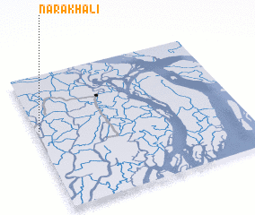 Places with similar names to Narakhāli, Bangladesh ::
Disclaimer :: Information on this page comes without warranty of any kind |
||
|
Where is Narakhāli? Elevation and coordinates ::
Latitude (lat): 22°36'0"N Longitude (lon): 90°1'0"E
(map arrows pan, magnifying glasses zoom) |
||
|
Visiting Narakhāli? Hotel/Accommodation ::
Book a hotel in Narakhāli Travel Guide ::
Buy a travel guide for Bangladesh rental cars ::
car rental offers GPS waypoint ::
download a GPX waypoint (PoI) of Narakhāli for your GPS receiver
|
||