|
search place name
|
||
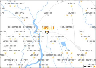
Susuli (Barisāl, Bangladesh)Susuli is a town in the Barisāl region of Bangladesh. An overview map of the region around Susuli is displayed below.
regional and 3d topo map of Susuli, Bangladesh ::
Susuli airports ::
The nearest airport is SPD - Saidpur, located 29.5 km south east of Susuli.
Other airports nearby include COH - Cooch-behar Cooch Behar (81.4 km north east), IXB - Baghdogra Bagdogra (88.0 km north west), BIR - Biratnagar (158.4 km west), PBH - Paro (171.0 km north east), Nearby towns ::
Jayganj (3.3km west) //
Kirttaniāpāra (3.8km south east) //
Kāsimnagar (3.8km south west) //
Alakjhāri (3.8km north west) //
Gorgrām (3.8km north east) //
Dukuri (4.1km south east) //
Bāsuli (5.0km south west) //
Sonāhār (7.4km north) //
Khalisāpacha (6.9km east) //
Prasādpāra (6.9km west) //
Bochapukur (7.6km south west) //
Krishnanagar (8.9km south west) //
Subarna Khuli (8.9km south east) //
Krishnapur (8.7km south west) //
Tangua (10.0km south east) //
Barāgācha (10.0km north east) //
[all distances 'as the bird flies' and approximate] 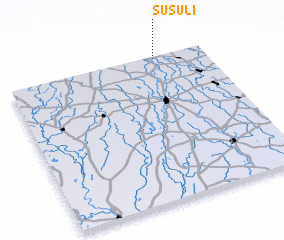 Places with similar names to Susuli, Bangladesh ::
Disclaimer :: Information on this page comes without warranty of any kind |
||
|
Where is Susuli? Elevation and coordinates ::
Latitude (lat): 25°59'0"N Longitude (lon): 88°45'0"E
Elevation (approx.): 52m (map arrows pan, magnifying glasses zoom) |
||
|
Visiting Susuli? Hotel/Accommodation ::
Book a hotel in Susuli Travel Guide ::
Buy a travel guide for Bangladesh rental cars ::
car rental offers GPS waypoint ::
download a GPX waypoint (PoI) of Susuli for your GPS receiver
|
||