|
search place name
|
||
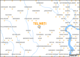
Telihāti (Barisāl, Bangladesh)Telihāti is a town in the Barisāl region of Bangladesh. An overview map of the region around Telihāti is displayed below.
regional and 3d topo map of Telihāti, Bangladesh ::
Telihāti airports ::
The nearest airport is DAC - Dhaka Zia Intl, located 45.1 km south of Telihāti.
Other airports nearby include IXA - Agartala (92.9 km south east), IRD - Ishurdi (139.3 km west), IXH - Kailashahar (161.6 km east), ZYL - Sylhet Osmani Osmany Intl (166.8 km north east), Nearby towns ::
Mulāid (1.9km south) //
Pelāid (2.5km north east) //
Tepirbāri (3.7km south) //
Jāmirdia (4.1km north west) //
Ujilāba (5.0km south east) //
Dhanua (5.0km north west) //
Kewa (5.6km south) //
Māona (5.4km west) //
Tengra (5.4km east) //
Kāsurgar (6.3km north west) //
Habirbāri (7.6km north) //
Bara Rāthura (7.5km south west) //
Lohāgāchh (8.1km south east) //
Jangirpur (8.1km north east) //
Dhāmlai (8.8km north east) //
Patka (9.0km south east) //
[all distances 'as the bird flies' and approximate]  Places with similar names to Telihāti, Bangladesh ::
Disclaimer :: Information on this page comes without warranty of any kind |
||
|
Where is Telihāti? Elevation and coordinates ::
Latitude (lat): 24°15'0"N Longitude (lon): 90°25'0"E
Elevation (approx.): 20m (map arrows pan, magnifying glasses zoom) |
||
|
Visiting Telihāti? Hotel/Accommodation ::
Book a hotel in Telihāti Travel Guide ::
Buy a travel guide for Bangladesh rental cars ::
car rental offers GPS waypoint ::
download a GPX waypoint (PoI) of Telihāti for your GPS receiver
|
||