|
search place name
|
||
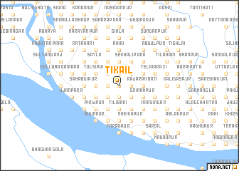
Tikail (Barisāl, Bangladesh)Tikail is a town in the Barisāl region of Bangladesh. An overview map of the region around Tikail is displayed below.
regional and 3d topo map of Tikail, Bangladesh ::
Tikail airports ::
The nearest airport is RJH - Rajshahi Shah Mokhdum, located 20.3 km east of Tikail.
Other airports nearby include IRD - Ishurdi (72.2 km south east), SPD - Saidpur (153.3 km north), JSR - Jessore (159.4 km south east), CCU - Calcutta Netaji Subhash Chandra Bose Intl (198.9 km south), Nearby towns ::
Sānkura (0.0km north) //
Brāhmangrām (0.0km north) //
Kānāitkunda (0.0km north) //
Gogrām (1.7km east) //
Jagpur (1.7km east) //
Sābāipur (1.7km west) //
Tirinda (1.7km west) //
Māchhmāra (1.7km west) //
Jote Parasurām (1.7km west) //
Dhātma (1.9km south) //
Nasaratpur (1.9km south) //
Terapāra (1.9km north) //
Bairāgitala (2.5km south east) //
Barsipāra (2.5km south east) //
Dadair (2.5km south east) //
Itāhāri (2.5km north east) //
Gopālpur (2.5km south west) //
Krorbāria (2.5km south west) //
Ādarpāra (2.5km south west) //
Sonādīghi (2.5km south west) //
Murāripur (2.5km north west) //
Mollāpāra (2.5km north west) //
Siāla (3.7km south) //
Tilibāri (3.7km south) //
Bāzeudpur (3.7km south) //
Naltri (3.7km north) //
Pānihār (3.7km north) //
Rājārambati (3.4km east) //
Birail (3.4km east) //
[all distances 'as the bird flies' and approximate] 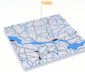 Places with similar names to Tikail, Bangladesh ::
Disclaimer :: Information on this page comes without warranty of any kind |
||
|
Where is Tikail? Elevation and coordinates ::
Latitude (lat): 24°27'0"N Longitude (lon): 88°25'0"E
Elevation (approx.): 28m (map arrows pan, magnifying glasses zoom) |
||
|
Visiting Tikail? Hotel/Accommodation ::
Book a hotel in Tikail Travel Guide ::
Buy a travel guide for Bangladesh rental cars ::
car rental offers GPS waypoint ::
download a GPX waypoint (PoI) of Tikail for your GPS receiver
|
||