|
search place name
|
||
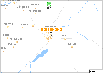
Boitshoko (South-East, Botswana)Boitshoko is a town in the South-East region of Botswana. An overview map of the region around Boitshoko is displayed below.
regional and 3d topo map of Boitshoko, Botswana ::
Boitshoko airports ::
The nearest airport is GBE - Gaberone Sir Seretse Khama Intl, located 11.8 km north of Boitshoko.
Other airports nearby include JWA - Jwaneng (125.2 km west), MBO - Mmabatho Mafikeng (131.6 km south), NTY - Pilanesberg Intl (146.3 km south east), MEZ - Messina Morningside Farm (152.2 km south east), Nearby towns ::
Botswelelo (0.6km north west) //
Dilalelo (0.6km south west) //
Mephato (0.8km south) //
Phologolo (1.1km north) //
Selemela (1.0km west) //
Borakanelo (1.0km west) //
The Mall (1.1km west) //
Gaberones Camp (1.1km south west) //
Village (1.3km south east) //
Badiri (1.3km north west) //
Sekgwa (1.6km west) //
Bontleng (1.7km south west) //
Madibeng (2.0km north west) //
Babusi (2.1km south west) //
Mmaraka (2.0km west) //
Gaborone (2.2km north west) //
Broadhurst (2.3km north) //
Naledi (3.3km south west) //
Tlokweng (4.6km east) //
Mogoditshane (7.2km north west) //
Mabutswe (7.8km south east) //
Dumadumana (9.8km north west) //
[all distances 'as the bird flies' and approximate] 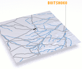 Places with similar names to Boitshoko, Botswana ::
Disclaimer :: Information on this page comes without warranty of any kind |
||
|
Where is Boitshoko? Elevation and coordinates ::
Latitude (lat): 24°39'41"S Longitude (lon): 25°55'34"E
Elevation (approx.): 997m (map arrows pan, magnifying glasses zoom) |
||
|
Visiting Boitshoko? Hotel/Accommodation ::
Book a hotel in Boitshoko Travel Guide ::
Buy a travel guide for Botswana rental cars ::
car rental offers GPS waypoint ::
download a GPX waypoint (PoI) of Boitshoko for your GPS receiver
|
||