|
search place name
|
||
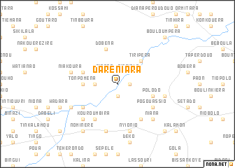
Daréniara (Burkina Faso)Daréniara is a town in Burkina Faso. An overview map of the region around Daréniara is displayed below.
regional and 3d topo map of Daréniara, Burkina Faso ::
Daréniara airports ::
The nearest airport is BOY - Bobo-dioulasso Bobo Dioulasso, located 184.2 km north west of Daréniara.
Nearby towns ::
Ponissio (1.9km south) //
Séni (1.9km south) //
Logouana (1.8km east) //
Dioulanpara (1.9km north) //
Nanbira (2.6km north east) //
Titara (2.6km north west) //
Tiobiala (2.6km north east) //
Nalahoudo (3.7km west) //
Tiripéra (5.2km north east) //
Tonpoména (5.5km west) //
Polodo (5.8km east) //
Pogouana (5.8km east) //
Dobéna (5.9km north) //
Kpapirao (5.8km west) //
Pogouassio (6.6km south east) //
Bénioudo (6.6km south east) //
Kotouroudo (6.6km south west) //
Binadio (6.7km south east) //
Kouroumbira (6.7km south west) //
Babayondo (6.7km south west) //
Kakoutan (7.6km south) //
Nyionio (7.6km south) //
Kosso (7.5km east) //
Niakoura (7.5km west) //
Biékiri (7.8km south west) //
Kilihoro (7.8km south east) //
Niana (7.8km south east) //
Kiripi (8.2km south west) //
Nominéré (9.2km south west) //
[all distances 'as the bird flies' and approximate]  Places with similar names to Daréniara, Burkina Faso ::
Disclaimer :: Information on this page comes without warranty of any kind |
||
|
Where is Daréniara? Elevation and coordinates ::
Latitude (lat): 9°53'0"N Longitude (lon): 3°15'0"W
Elevation (approx.): 288m (map arrows pan, magnifying glasses zoom) |
||
|
Visiting Daréniara? Hotel/Accommodation ::
Book a hotel in Daréniara Travel Guide ::
rental cars ::
car rental offers GPS waypoint ::
download a GPX waypoint (PoI) of Daréniara for your GPS receiver
|
||