|
search place name
|
||
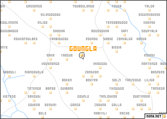
Goungla (Burkina Faso)Goungla is a town in Burkina Faso. An overview map of the region around Goungla is displayed below.
regional and 3d topo map of Goungla, Burkina Faso ::
Goungla airports ::
The nearest airport is OUA - Ouagadougou, located 90.2 km south of Goungla.
Nearby towns ::
Ouazeulé (1.9km north) //
Yaogué (3.6km west) //
Signoren (3.7km south) //
Rounou (4.1km north east) //
Imiougou (4.1km south east) //
Zandkom (4.1km south east) //
Togoma (5.2km south east) //
Bouyra (5.8km south) //
Tambiougou (6.6km north west) //
Bissiguen (6.6km north east) //
Sabsé (6.6km north east) //
Boken (6.6km south west) //
Boussouma (6.6km north east) //
Raka (7.2km west) //
Vousnango (7.5km west) //
Bissia (7.5km east) //
Shouma (7.8km north west) //
Guibaré (8.2km south west) //
Rouko (9.1km north west) //
Foulou (9.2km north east) //
Solzi (9.1km south east) //
Konkoubougui (10.3km north west) //
Nô (10.3km north east) //
Tensobadogo (10.3km north east) //
Barsa (10.3km south west) //
Yikoudgo (10.3km south east) //
[all distances 'as the bird flies' and approximate]  Places with similar names to Goungla, Burkina Faso ::
Disclaimer :: Information on this page comes without warranty of any kind |
||
|
Where is Goungla? Elevation and coordinates ::
Latitude (lat): 13°10'0"N Longitude (lon): 1°34'0"W
Elevation (approx.): 321m (map arrows pan, magnifying glasses zoom) |
||
|
Visiting Goungla? Hotel/Accommodation ::
Book a hotel in Goungla Travel Guide ::
rental cars ::
car rental offers GPS waypoint ::
download a GPX waypoint (PoI) of Goungla for your GPS receiver
|
||