|
search place name
|
||
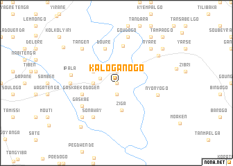
Kaloganogo (Burkina Faso)Kaloganogo is a town in Burkina Faso. An overview map of the region around Kaloganogo is displayed below.
regional and 3d topo map of Kaloganogo, Burkina Faso ::
Kaloganogo airports ::
The nearest airport is OUA - Ouagadougou, located 51.0 km south west of Kaloganogo.
Nearby towns ::
Kanpenga (0.0km north) //
Nambingen (1.9km south) //
Laougou (1.9km north) //
Sawana (2.7km west) //
Ganganden (3.6km west) //
Basbyédo (4.1km north west) //
Ziga (4.5km south) //
Douré (5.8km north) //
Gaskaé Kodogen (5.7km west) //
Béta (6.0km north) //
Sonaway (6.6km south west) //
Gaskaé (6.6km south west) //
Nyonyogo (6.8km east) //
Ipala (7.2km west) //
Datagma (7.2km west) //
Goudogo (7.6km north) //
Signogen (7.8km south west) //
Nyaré (7.8km north east) //
Tangen (7.8km north west) //
Absouya (8.0km north east) //
Togom Bangré (9.1km south west) //
Largo (9.1km north east) //
Batenga (9.2km north east) //
Kogotenga (9.2km north east) //
Sangpelsé (10.1km north west) //
Tampaogo (10.4km north east) //
[all distances 'as the bird flies' and approximate] 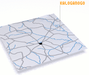 Places with similar names to Kaloganogo, Burkina Faso ::
Disclaimer :: Information on this page comes without warranty of any kind |
||
|
Where is Kaloganogo? Elevation and coordinates ::
Latitude (lat): 12°36'0"N Longitude (lon): 1°7'0"W
Elevation (approx.): 282m (map arrows pan, magnifying glasses zoom) |
||
|
Visiting Kaloganogo? Hotel/Accommodation ::
Book a hotel in Kaloganogo Travel Guide ::
rental cars ::
car rental offers GPS waypoint ::
download a GPX waypoint (PoI) of Kaloganogo for your GPS receiver
|
||