|
search place name
|
||
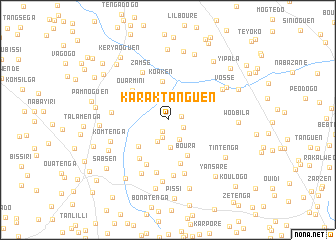
Karaktanguen (Bazèga, Burkina Faso)Karaktanguen is a town in the Bazèga region of Burkina Faso. An overview map of the region around Karaktanguen is displayed below.
regional and 3d topo map of Karaktanguen, Burkina Faso ::
Karaktanguen airports ::
The nearest airport is OUA - Ouagadougou, located 22.4 km north of Karaktanguen.
Nearby towns ::
Kiépalogo (1.4km south west) //
Bointenga (1.6km east) //
Diépo (1.9km south east) //
Kounda (2.1km south) //
Sologo (2.5km south east) //
Téwodogo (2.6km south west) //
Lilbouré (3.0km north) //
Bougren (3.1km south) //
Yargo (3.7km north west) //
Koaken (4.3km north) //
Kiéden (4.4km south west) //
Boura (4.5km south east) //
Bonkoré (5.1km south) //
Ouarmini (5.1km north west) //
Kousoulougou (5.3km south west) //
Bagaben (5.5km south west) //
Gounguen (5.9km south) //
Zamsé (6.0km north west) //
Nakomogo (6.2km south) //
Silmiougou (6.3km south) //
Jourès Ouidi (6.2km west) //
Dawélgué (6.6km south west) //
Komtenga (6.8km west) //
Doumtenga (6.9km south) //
Tibé (6.9km north east) //
Kosmassem (7.3km south west) //
Vossé (7.3km north east) //
Tintenga (7.6km south east) //
Gonsé (7.5km west) //
[all distances 'as the bird flies' and approximate]  Places with similar names to Karaktanguen, Burkina Faso ::
// Carrigdangan (IE)
Disclaimer :: Information on this page comes without warranty of any kind |
||
|
Where is Karaktanguen? Elevation and coordinates ::
Latitude (lat): 12°9'8"N Longitude (lon): 1°29'16"W
Elevation (approx.): 301m (map arrows pan, magnifying glasses zoom) |
||
|
Visiting Karaktanguen? Hotel/Accommodation ::
Book a hotel in Karaktanguen Travel Guide ::
rental cars ::
car rental offers GPS waypoint ::
download a GPX waypoint (PoI) of Karaktanguen for your GPS receiver
|
||