|
search place name
|
||
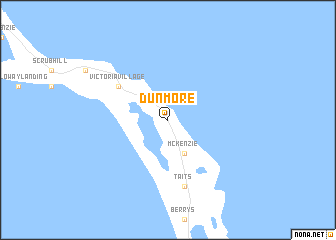
Dunmore (Long Island, Bahamas, The)Dunmore is a town in the Long Island region of Bahamas, The. An overview map of the region around Dunmore is displayed below.
regional and 3d topo map of Dunmore, Bahamas, The ::
Dunmore airports ::
The nearest airport is LGI - Dead Man's Cay Deadmans Cay, located 24.4 km north west of Dunmore.
Other airports nearby include SML - Stella Maris (70.0 km north west), GGT - George Town (101.3 km north west), GGT - Great Exuma Exuma Intl (115.0 km north west), AXP - Spring Point (116.8 km south east), Nearby towns ::
Hard Bargain (4.1km south east) //
McKenzie (4.1km south east) //
Victoria Village (6.3km north west) //
Roses (7.6km south) //
Taits (7.6km south) //
[all distances 'as the bird flies' and approximate]  Places with similar names to Dunmore, Bahamas, The ::
// Tinoumirra (MA)
// Tinoummer (MA)
// Tanah Merah (MY)
// Dona Maria (PT)
// Dona Maria (PT)
// Dona Maria (PT)
// Doña María (CU)
// Donamaría (ES)
// Deh Nowmīr (IR)
// Dunmor (US)
Disclaimer :: Information on this page comes without warranty of any kind |
||
|
Where is Dunmore? Elevation and coordinates ::
Latitude (lat): 23°3'0"N Longitude (lon): 74°54'0"W
Elevation (approx.): 16m (map arrows pan, magnifying glasses zoom) |
||
|
Visiting Dunmore? Hotel/Accommodation ::
Book a hotel in Dunmore Travel Guide ::
rental cars ::
car rental offers GPS waypoint ::
download a GPX waypoint (PoI) of Dunmore for your GPS receiver
|
||