|
search place name
|
||
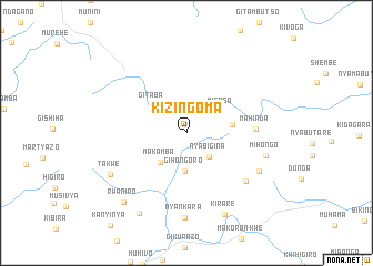
Kizingoma (Makamba, Burundi)Kizingoma is a town in the Makamba region of Burundi. An overview map of the region around Kizingoma is displayed below.
regional and 3d topo map of Kizingoma, Burundi ::
Kizingoma airports ::
The nearest airport is BJM - Bujumbura Intl, located 103.6 km north west of Kizingoma.
Other airports nearby include FMI - Kalemie (205.7 km south), KME - Kamembe (208.8 km north west), BKY - Bukavu/kavumu Bukavu Kavumu (229.0 km north west), Nearby towns ::
Nyabigina (3.3km south east) //
Gihongoro (3.8km south) //
Makamba (3.9km south west) //
Misasa (4.1km north east) //
Gitaba (4.3km north west) //
Kinoso (4.7km east) //
Mahinda (7.0km east) //
Mutare (7.7km south east) //
Nyange (8.3km south east) //
Mihongo (8.3km east) //
Nyankara (8.5km south) //
Takwe (8.8km south west) //
Kirare (9.1km south east) //
Rwaniro (9.3km south west) //
Gisenyi (9.4km south west) //
[all distances 'as the bird flies' and approximate] 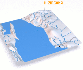 Places with similar names to Kizingoma, Burundi ::
// Gusoon Gamay (PH)
// Kasonkama (CD)
// Kizengamu (CD)
// Kasangombe (UG)
// Kasungami (ZM)
// Kisengam (PG)
Disclaimer :: Information on this page comes without warranty of any kind |
||
|
Where is Kizingoma? Elevation and coordinates ::
Latitude (lat): 4°6'31"S Longitude (lon): 29°49'43"E
Elevation (approx.): 1539m (map arrows pan, magnifying glasses zoom) |
||
|
Visiting Kizingoma? Hotel/Accommodation ::
Book a hotel in Kizingoma Travel Guide ::
Buy a travel guide for Burundi rental cars ::
car rental offers GPS waypoint ::
download a GPX waypoint (PoI) of Kizingoma for your GPS receiver
|
||