|
search place name
|
||
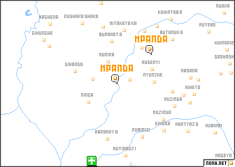
Mpanda (Bubanza, Burundi)Mpanda is a town in the Bubanza region of Burundi. An overview map of the region around Mpanda is displayed below.
regional and 3d topo map of Mpanda, Burundi ::
Mpanda airports ::
The nearest airport is BJM - Bujumbura Intl, located 13.0 km south of Mpanda.
Other airports nearby include KME - Kamembe (96.7 km north west), BKY - Bukavu/kavumu Bukavu Kavumu (117.0 km north west), KGL - Kigali Intl (162.8 km north east), GYI - Gisenyi (170.1 km north), Nearby towns ::
Kigwati (2.0km east) //
Murira (3.9km north west) //
Nyeshanga (4.1km west) //
Ninga (5.5km south west) //
Nyunzwe (5.8km east) //
Musenyi (6.0km north east) //
Buramata (6.9km north) //
Rambwe (6.9km north east) //
Gihanga (7.0km west) //
Mpanda (7.1km north east) //
Mitakataka (8.6km north) //
Mubungere (8.8km east) //
Maramvya (9.0km south) //
Muzinda (9.2km south east) //
Rubirizi (9.4km south east) //
Nyabugoye (9.5km north east) //
Kivoga (10.6km south east) //
Butanuka (11.3km north east) //
[all distances 'as the bird flies' and approximate] 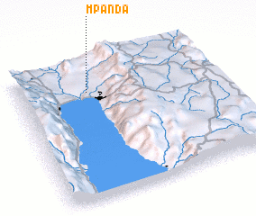 Places with similar names to Mpanda, Burundi ::
Disclaimer :: Information on this page comes without warranty of any kind |
||
|
Where is Mpanda? Elevation and coordinates ::
Latitude (lat): 3°12'45"S Longitude (lon): 29°21'20"E
Elevation (approx.): 829m (map arrows pan, magnifying glasses zoom) |
||
|
Visiting Mpanda? Hotel/Accommodation ::
Book a hotel in Mpanda Travel Guide ::
Buy a travel guide for Burundi rental cars ::
car rental offers GPS waypoint ::
download a GPX waypoint (PoI) of Mpanda for your GPS receiver
|
||