|
search place name
|
||
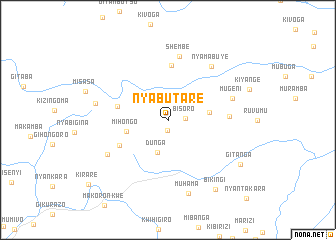
Nyabutare (Makamba, Burundi)Nyabutare is a town in the Makamba region of Burundi. An overview map of the region around Nyabutare is displayed below.
regional and 3d topo map of Nyabutare, Burundi ::
Nyabutare airports ::
The nearest airport is BJM - Bujumbura Intl, located 111.9 km north west of Nyabutare.
Other airports nearby include FMI - Kalemie (209.0 km south), KME - Kamembe (216.2 km north west), BKY - Bukavu/kavumu Bukavu Kavumu (236.4 km north west), Nearby towns ::
Kayogoro (1.2km south) //
Bisoro (1.9km east) //
Dunga (3.8km south) //
Kidagarazi (4.7km east) //
Mihongo (4.8km west) //
Mahinda (5.9km west) //
Nyange (6.1km south west) //
Gitabi (6.1km north) //
Muyaga (6.9km east) //
Shembe (7.2km north) //
Mugeni (7.6km east) //
Nyamabuye (7.6km north east) //
Mutare (7.8km south west) //
Kinoso (8.3km west) //
Muhama (8.5km south) //
Bikingi (9.4km south east) //
Gitanga (9.5km south east) //
Kirare (11.4km south west) //
Nyantakara (12.3km south east) //
[all distances 'as the bird flies' and approximate] 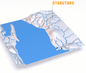
Disclaimer :: Information on this page comes without warranty of any kind |
||
|
Where is Nyabutare? Elevation and coordinates ::
Latitude (lat): 4°7'5"S Longitude (lon): 29°56'34"E
Elevation (approx.): 1404m (map arrows pan, magnifying glasses zoom) |
||
|
Visiting Nyabutare? Hotel/Accommodation ::
Book a hotel in Nyabutare Travel Guide ::
Buy a travel guide for Burundi rental cars ::
car rental offers GPS waypoint ::
download a GPX waypoint (PoI) of Nyabutare for your GPS receiver
|
||