|
search place name
|
||
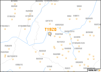
Tyazo (Ngozi, Burundi)Tyazo is a town in the Ngozi region of Burundi. An overview map of the region around Tyazo is displayed below.
regional and 3d topo map of Tyazo, Burundi ::
Tyazo airports ::
The nearest airport is BJM - Bujumbura Intl, located 77.4 km south west of Tyazo.
Other airports nearby include KGL - Kigali Intl (99.8 km north east), KME - Kamembe (102.4 km west), BKY - Bukavu/kavumu Bukavu Kavumu (119.3 km north west), GYI - Gisenyi (135.5 km north west), Nearby towns ::
Ryarumuri (1.5km east) //
Migende (3.4km east) //
Kiryama (4.2km south) //
Gatete (4.5km north) //
Karenga (4.6km north east) //
Kavumu (4.8km south) //
Ruyenzi (5.2km south east) //
Kiziba (6.7km south east) //
Busiga (7.2km south) //
Musezero (7.2km east) //
Kabataha (7.7km east) //
Kivoga (7.7km east) //
Kunkubi (8.0km south west) //
Mwumba (8.3km south) //
Kandaro (8.4km south east) //
Mihama (8.7km south east) //
Magi (9.5km north east) //
Kiyonza (10.0km north west) //
Buye (10.0km south east) //
Kigembe (10.3km north west) //
Murama (11.2km north west) //
[all distances 'as the bird flies' and approximate]  Places with similar names to Tyazo, Burundi ::
Disclaimer :: Information on this page comes without warranty of any kind |
||
|
Where is Tyazo? Elevation and coordinates ::
Latitude (lat): 2°47'25"S Longitude (lon): 29°46'9"E
Elevation (approx.): 1550m (map arrows pan, magnifying glasses zoom) |
||
|
Visiting Tyazo? Hotel/Accommodation ::
Book a hotel in Tyazo Travel Guide ::
Buy a travel guide for Burundi rental cars ::
car rental offers GPS waypoint ::
download a GPX waypoint (PoI) of Tyazo for your GPS receiver
|
||