|
search place name
|
||
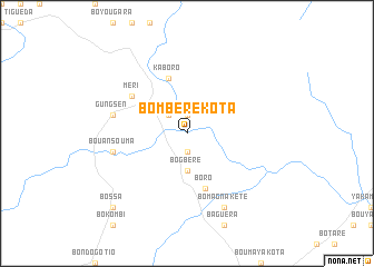
Bombéré-Kota (Central African Republic)Bombéré-Kota is a town in Central African Republic. An overview map of the region around Bombéré-Kota is displayed below.
regional and 3d topo map of Bombéré-Kota, Central African Republic ::
Bombéré-Kota airports ::
The nearest airport is MQQ - Moundou, located 249.4 km north west of Bombéré-Kota.
Nearby towns ::
Bombéré-Kété (1.9km south) //
Kakouda (1.9km south) //
Karoumba (1.9km south) //
Fikabila (1.9km north) //
Kadera (1.9km north) //
Bogalé-Kota (2.6km north west) //
Bogbéré (3.7km south) //
Boro (5.9km south) //
Bondoro (5.9km south) //
Bogago (5.9km south) //
Kaboro (5.9km north) //
Méri (6.6km north west) //
Bogali-Keté (6.6km north west) //
Bouansouma (7.6km west) //
Gungsen (7.6km west) //
Bobonzoulé (8.3km south east) //
Bomagna-Kété (8.3km south east) //
Bossa (10.4km south west) //
Bonokon (10.4km south west) //
[all distances 'as the bird flies' and approximate] 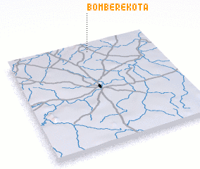 Places with similar names to Bombéré-Kota, Central African Republic ::
// Bombara-Kota (CF)
// Bombéré-Kété (CF)
// Bambou Rigaud (HT)
// Bambaragoda (LK)
// Bambaragoda (LK)
Disclaimer :: Information on this page comes without warranty of any kind |
||
|
Where is Bombéré-Kota? Elevation and coordinates ::
Latitude (lat): 6°56'0"N Longitude (lon): 17°34'0"E
Elevation (approx.): 498m (map arrows pan, magnifying glasses zoom) |
||
|
Visiting Bombéré-Kota? Hotel/Accommodation ::
Book a hotel in Bombéré-Kota Travel Guide ::
rental cars ::
car rental offers GPS waypoint ::
download a GPX waypoint (PoI) of Bombéré-Kota for your GPS receiver
|
||