|
search place name
|
||
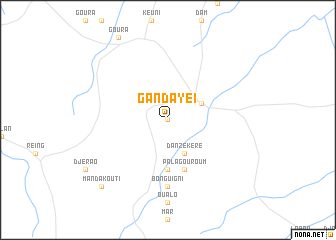
Gandaye I (Logone Occidental, Chad)Gandaye I is a town in the Logone Occidental region of Chad. An overview map of the region around Gandaye I is displayed below.
regional and 3d topo map of Gandaye I, Chad ::
Gandaye I airports ::
The nearest airport is MQQ - Moundou, located 79.5 km east of Gandaye I.
Other airports nearby include GOU - Garoua (230.5 km west), MVR - Maroua Salak (232.6 km north west), NGE - N'gaoundere Ngaoundere (243.8 km south west), Nearby towns ::
Gandaye II (0.0km north) //
Beinamar (4.1km north east) //
Danzékéré (4.1km south east) //
Dao (5.6km south) //
Palagouroum (5.9km south) //
Bonguigni (7.4km south) //
Manda Kouti (10.4km south west) //
[all distances 'as the bird flies' and approximate]  Places with similar names to Gandaye I, Chad ::
// Kendya (RU)
// Konduya (RU)
// Cundiyo (US)
// Kandaye (BF)
// Kondaya (BF)
// Gandaye II (TD)
// Kondya (IN)
// Kannattiya (LK)
// Gandiaye (SN)
// Gondiaye (SN)
Disclaimer :: Information on this page comes without warranty of any kind |
||
|
Where is Gandaye I? Elevation and coordinates ::
Latitude (lat): 8°39'0"N Longitude (lon): 15°21'0"E
Elevation (approx.): 454m (map arrows pan, magnifying glasses zoom) |
||
|
Visiting Gandaye I? Hotel/Accommodation ::
Book a hotel in Gandaye I Travel Guide ::
Buy a travel guide for Chad rental cars ::
car rental offers GPS waypoint ::
download a GPX waypoint (PoI) of Gandaye I for your GPS receiver
|
||