|
search place name
|
||
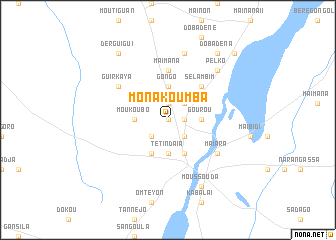
Monakoumba (Moyen-Chari, Chad)Monakoumba is a town in the Moyen-Chari region of Chad. An overview map of the region around Monakoumba is displayed below.
regional and 3d topo map of Monakoumba, Chad ::
Monakoumba airports ::
The nearest airport is MQQ - Moundou, located 186.7 km west of Monakoumba.
Nearby towns ::
Ndohorininga (0.0km north) //
Maïkan (1.8km east) //
Kaba I (1.9km north) //
Bodo (1.9km north) //
Morko (2.6km south east) //
Doninga (2.6km south west) //
Maïbara (2.6km north east) //
Nodjibodo (2.6km north east) //
Moukoubo (3.7km west) //
Gourou (3.7km east) //
Tétindaïa (3.7km south) //
Maïmbaga (3.7km south) //
Gongo (3.7km north) //
Moïssala (4.1km south east) //
Gaïra (4.1km south west) //
Sélambim (5.2km north east) //
Maïmana (5.6km north) //
Maïara (6.6km south east) //
Guirkaya (6.6km north west) //
Bétigadjia (7.6km north) //
Pelko (7.8km north east) //
Moussouda (8.3km south east) //
Derguigui (9.2km north west) //
Doba-Dena (9.2km north east) //
Doba (10.4km north east) //
[all distances 'as the bird flies' and approximate] 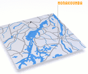 Places with similar names to Monakoumba, Chad ::
Disclaimer :: Information on this page comes without warranty of any kind |
||
|
Where is Monakoumba? Elevation and coordinates ::
Latitude (lat): 8°23'0"N Longitude (lon): 17°45'0"E
Elevation (approx.): 387m (map arrows pan, magnifying glasses zoom) |
||
|
Visiting Monakoumba? Hotel/Accommodation ::
Book a hotel in Monakoumba Travel Guide ::
Buy a travel guide for Chad rental cars ::
car rental offers GPS waypoint ::
download a GPX waypoint (PoI) of Monakoumba for your GPS receiver
|
||