|
search place name
|
||
Ouled Issa (Batha, Chad)Ouled Issa is a town in the Batha region of Chad. An overview map of the region around Ouled Issa is displayed below.
regional and 3d topo map of Ouled Issa, Chad ::
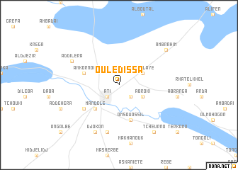
Nearby towns ::
Abjouet (2.6km south east) //
Ati (2.6km south west) //
Abroki (4.1km south east) //
Am Malaye (4.1km north east) //
Mandelé (5.2km south west) //
Am Souassil (5.8km south) //
Am Kornoï (5.7km west) //
Abachta (6.6km south west) //
Am Targay (7.6km south) //
Djokan (8.2km south west) //
Addilera (8.1km north west) //
Tcheurno (9.2km south east) //
Am Brahim (9.1km north east) //
[all distances 'as the bird flies' and approximate] 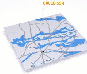 Places with similar names to Ouled Issa, Chad ::
// Oulad Aïssa (MA)
// Oulad Aïssa (MA)
// Oulad Aïssa (MA)
// Oulad Aïssa (MA)
// Oulad Aïssa (MA)
// Oulad Aïssa (MA)
// Oulad Zaouia (MA)
// Olds (US)
// Ołudza (PL)
// Oulad Aissa (TN)
Disclaimer :: Information on this page comes without warranty of any kind |
||
|
Where is Ouled Issa? Elevation and coordinates ::
Latitude (lat): 13°14'0"N Longitude (lon): 18°21'0"E
Elevation (approx.): 335m (map arrows pan, magnifying glasses zoom) |
||
|
Visiting Ouled Issa? Hotel/Accommodation ::
Book a hotel in Ouled Issa Travel Guide ::
Buy a travel guide for Chad rental cars ::
car rental offers GPS waypoint ::
download a GPX waypoint (PoI) of Ouled Issa for your GPS receiver
|
||