|
search place name
|
||
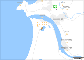
Quiapo (Biobío, Chile)Quiapo is a town in the Biobío region of Chile. An overview map of the region around Quiapo is displayed below.
regional and 3d topo map of Quiapo, Chile ::
Quiapo airports ::
The nearest airport is CCP - Concepcion Carriel Sur Intl, located 11.5 km north east of Quiapo.
Other airports nearby include LSQ - Los Angeles Maria Dolores (85.4 km south east), ZCO - Temuco Maquehue (215.1 km south), Nearby towns ::
Loma Colorada (2.4km north west) //
La Boca (5.6km north) //
Concepción (7.0km north east) //
[all distances 'as the bird flies' and approximate]  Places with similar names to Quiapo, Chile ::
Disclaimer :: Information on this page comes without warranty of any kind |
||
|
Where is Quiapo? Elevation and coordinates ::
Latitude (lat): 36°52'0"S Longitude (lon): 73°7'0"W
Elevation (approx.): 13m (map arrows pan, magnifying glasses zoom) |
||
|
Visiting Quiapo? Hotel/Accommodation ::
Book a hotel in Quiapo Travel Guide ::
Buy a travel guide for Chile rental cars ::
car rental offers GPS waypoint ::
download a GPX waypoint (PoI) of Quiapo for your GPS receiver
|
||