|
search place name
|
||
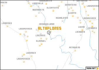
Alta Flores (Santander, Colombia)Alta Flores is a town in the Santander region of Colombia. An overview map of the region around Alta Flores is displayed below.
regional and 3d topo map of Alta Flores, Colombia ::
Alta Flores airports ::
The nearest airport is EJA - Barrancabermeja Yariguies, located 42.9 km north of Alta Flores.
Other airports nearby include BGA - Bucaramanga Palonegro (90.1 km north east), OTU - Otu (105.5 km north west), MDE - Rio Negro Jose Maria Cordova (183.1 km west), OCV - Ocana Aguas Claras (192.9 km north), Nearby towns ::
Las Raleras (1.3km north) //
Agua Bonita (1.7km south) //
El Dorado (1.8km south west) //
Las Cruces (2.2km north) //
Brisas del Opón (3.2km north) //
La Reforma (3.4km west) //
Los Canos (3.5km west) //
El Vergel (4.6km south west) //
El Tesoro (4.7km north west) //
La India (5.3km north west) //
Buenos Aires (5.5km south west) //
Agua Blanca (7.3km north east) //
El Delirio (8.3km west) //
Campo Capote (8.8km west) //
La Coquera (9.0km north west) //
Buenavista (9.4km north west) //
La Venada (10.5km south west) //
El Danto (11.4km north east) //
[all distances 'as the bird flies' and approximate]  Places with similar names to Alta Flores, Colombia ::
// Alto Villaraso (CO)
Disclaimer :: Information on this page comes without warranty of any kind |
||
|
Where is Alta Flores? Elevation and coordinates ::
Latitude (lat): 6°38'14"N Longitude (lon): 73°50'12"W
Elevation (approx.): 117m (map arrows pan, magnifying glasses zoom) |
||
|
Visiting Alta Flores? Hotel/Accommodation ::
Book a hotel in Alta Flores Travel Guide ::
Buy a travel guide for Colombia rental cars ::
car rental offers GPS waypoint ::
download a GPX waypoint (PoI) of Alta Flores for your GPS receiver
|
||