|
search place name
|
||
Altamira (Santander, Colombia)Altamira is a town in the Santander region of Colombia. An overview map of the region around Altamira is displayed below.
regional and 3d topo map of Altamira, Colombia ::

Altamira airports ::
The nearest airport is EJA - Barrancabermeja Yariguies, located 118.6 km north of Altamira.
Other airports nearby include OTU - Otu (141.0 km north west), BOG - Bogota Eldorado Intl (141.1 km south), BGA - Bucaramanga Palonegro (155.7 km north east), MDE - Rio Negro Jose Maria Cordova (160.9 km west), Nearby towns ::
Rodeo (1.8km west) //
La Esperanza (2.7km north west) //
San Vicente (3.1km west) //
Mirador (3.4km west) //
Líbano (3.7km east) //
Paujillo (3.7km north west) //
La Quitaz (4.6km south west) //
La Copa (4.8km west) //
Miravalles (4.9km south west) //
Santa Rita (5.6km north) //
Lagunas de Sailán (6.1km south west) //
La Libertad (6.4km north west) //
Sabanagrande (6.7km north east) //
Palmaral (6.8km south west) //
Volcondia (7.8km south) //
Sevilla (9.2km south west) //
El Achontillo (10.6km south west) //
[all distances 'as the bird flies' and approximate] 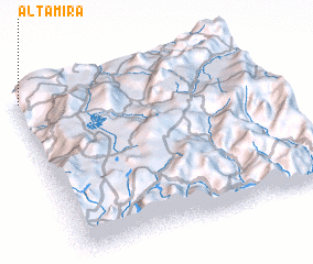 Places with similar names to Altamira, Colombia ::
Disclaimer :: Information on this page comes without warranty of any kind |
||
|
Where is Altamira? Elevation and coordinates ::
Latitude (lat): 5°58'0"N Longitude (lon): 73°59'0"W
Elevation (approx.): 781m (map arrows pan, magnifying glasses zoom) |
||
|
Visiting Altamira? Hotel/Accommodation ::
Book a hotel in Altamira Travel Guide ::
Buy a travel guide for Colombia rental cars ::
car rental offers GPS waypoint ::
download a GPX waypoint (PoI) of Altamira for your GPS receiver
|
||