|
search place name
|
||
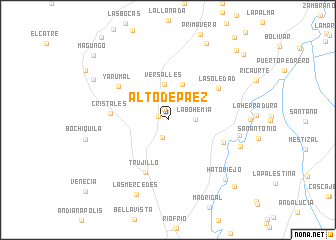
Alto de Páez (Valle del Cauca, Colombia)Alto de Páez is a town in the Valle del Cauca region of Colombia. An overview map of the region around Alto de Páez is displayed below.
regional and 3d topo map of Alto de Páez, Colombia ::
Alto de Páez airports ::
The nearest airport is ULQ - Tulua Farfan, located 21.0 km south of Alto de Páez.
Other airports nearby include AXM - Armenia El Eden (62.7 km east), CLO - Cali Alfonso Bonilla Aragon Intl (80.5 km south), PEI - Pereira Matecana (86.7 km north east), BUN - Buenaventura Gerardo Tobar Lopez (91.2 km south west), Nearby towns ::
La Luisa (1.1km west) //
Adriene Morano (1.3km north) //
La Marina (2.0km south) //
La Bohemia (3.1km east) //
Versalles (4.0km north) //
Cerro Azul (4.3km north) //
Trujillo (6.3km south west) //
Cristales (6.4km west) //
Huasanó (6.6km east) //
La Soledad (6.6km north east) //
Yarumal (6.7km north west) //
Robledo (8.2km east) //
Almorzadero (8.6km east) //
Las Mercedes (9.0km south west) //
Hato Viejo (9.2km south east) //
Dosquebradas (9.5km north west) //
Guacos (9.6km north east) //
Oriente (10.5km south east) //
Montañuela (10.9km north east) //
Magungo (11.0km north west) //
Escondido (11.2km north east) //
[all distances 'as the bird flies' and approximate]  Places with similar names to Alto de Páez, Colombia :: Disclaimer :: Information on this page comes without warranty of any kind |
||
|
Where is Alto de Páez? Elevation and coordinates ::
Latitude (lat): 4°16'0"N Longitude (lon): 76°18'0"W
Elevation (approx.): 1741m (map arrows pan, magnifying glasses zoom) |
||
|
Visiting Alto de Páez? Hotel/Accommodation ::
Book a hotel in Alto de Páez Travel Guide ::
Buy a travel guide for Colombia rental cars ::
car rental offers GPS waypoint ::
download a GPX waypoint (PoI) of Alto de Páez for your GPS receiver
|
||