|
search place name
|
||
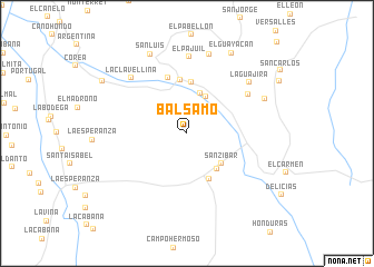
Bálsamo (Santander, Colombia)Bálsamo is a town in the Santander region of Colombia. An overview map of the region around Bálsamo is displayed below.
regional and 3d topo map of Bálsamo, Colombia ::
Bálsamo airports ::
The nearest airport is EJA - Barrancabermeja Yariguies, located 39.5 km north west of Bálsamo.
Other airports nearby include BGA - Bucaramanga Palonegro (63.2 km north east), OTU - Otu (127.0 km west), OCV - Ocana Aguas Claras (177.0 km north), SVZ - San Antonio Del Tachira (177.2 km north east), Nearby towns ::
La Llana (4.1km north east) //
El Chucho (4.2km north) //
San Zibar (4.6km south east) //
Tierra Grata (4.7km south east) //
Centenario (5.1km south east) //
Miraflores (5.1km north) //
Campo El Veintisiete (5.4km north) //
Dos Bocas (5.9km north) //
Aljibes (7.3km north east) //
El Pajuil (7.7km north) //
La Clavellina (7.8km north west) //
La Guajira (8.0km north east) //
El Cerrito (8.2km north) //
El Toboso (8.5km north east) //
San Luis (8.8km north west) //
El Guayacán (9.2km north east) //
Las Clavellinas (10.0km north west) //
[all distances 'as the bird flies' and approximate]  Places with similar names to Bálsamo, Colombia ::
Disclaimer :: Information on this page comes without warranty of any kind |
||
|
Where is Bálsamo? Elevation and coordinates ::
Latitude (lat): 6°44'0"N Longitude (lon): 73°36'0"W
Elevation (approx.): 266m (map arrows pan, magnifying glasses zoom) |
||
|
Visiting Bálsamo? Hotel/Accommodation ::
Book a hotel in Bálsamo Travel Guide ::
Buy a travel guide for Colombia rental cars ::
car rental offers GPS waypoint ::
download a GPX waypoint (PoI) of Bálsamo for your GPS receiver
|
||